1718 Tongwei–Gansu earthquake
Earthquake in China
35°00′N 105°12′E / 35.0°N 105.2°E / 35.0; 105.2[2]An earthquake occurred on June 19, 1718, in Tongwei County, Gansu Province, Qing dynasty, present-day China. The estimated surface wave magnitude (Ms ) 7.5 earthquake was designated a maximum Modified Mercalli intensity of X (Extreme), causing tremendous damage and killing 73,000 people.[2]
Tectonic setting
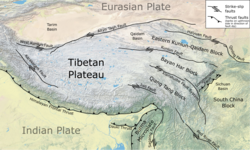
The active plate tectonics of Gansu Province located on the Tibetan Plateau is dominated by the north–south continental collision of the Indian Plate and Eurasian Plate. As the Indian Plate collides along a convergent plate boundary known as the Main Himalayan Thrust, it being of continental crust does not subduct: rather, it ploughs into the Eurasian Plate. This process severely deforms the Eurasian Plate, uplifting the crust, forming the Tibetan Plateau. The force of the Indian Plate converging pushes the Tibetan Plateau east, towards the Sichuan Basin, forming another zone of collision. This collision and resulting crustal deformation of the Eurasian Plate is accommodated by the Xianshuihe fault system, Haiyuan Fault, Kunlun Fault, Altyn Tagh fault, and Longmenshan Fault. The presence of active faults in Gansu makes the region vulnerable to damaging earthquakes. The very deadly 2008 Sichuan earthquake occurred due to a thrust fault rupture on the Longmenshan Fault.[3] The 1920 Haiyuan and 1927 Gulang earthquakes occurred due to ruptures along the Haiyuan Fault.
Earthquake
The West Qinling Fault in the Tibetan plateau, an active left–lateral strike-slip fault, was proposed as the source of the earthquake, although there is no seismological evidence to prove this. In the centuries since the event, the fault has not produced any major earthquakes.[4] Another proposed source is the adjacent Tongwei thrust fault, although little is known about its associated seismic activity. No surface ruptures from the earthquake has been documented, suggesting it may be a buried rupture earthquake.[5]
Effects
The earthquake gained notable scientific attention due to the triggering of over 300 large landslides. Many of these slides consisted of several meters of loess and mudstone deposits along steep mountainsides near the Wei River. Three of the largest landslides in Pan'an, Tianshui, Gangu County, had a combined volume of 6.06 × 10⁸ m3.[6] Locating the distribution of landslides using Google Earth found a dense concentration of occurrence along the Tongwei Fault.[5]
Damage
All structures including government offices, schools, temples, and homes in Nanxiang were destroyed. It was reported that the only surviving structure was a portion of the brick city wall at the northeast corner of the city. Over 40,000 people were killed in the city. Another 30,000 people died in Yongning when massive landslides buried many homes in the area. Ground effects were severe; large fissures appeared and the landscape was deformed.[2] A large landslide completely buried Yongning Ancient Town during the quake.
Several mountain peaks including one at Jingning County detached and fell, damming a river, and killing several thousand. In Zhuanglang County, a large hill suffered a landslide, resulting in thousands of deaths. Many gate towers, pavilions, and battlements in Qin'an County were destroyed.[2]
In Tianshui, the earthquake collapsed Confucian Temples and homes. Ground fissures and landslides killed some residents. Smaller fatality figures were reported in other parts of Gansu Province. The earthquake also affected Shaanxi and Henan provinces.[2]
See also
References
- ^ a b "Global Historical Earthquake Archive". emidius.eu. Retrieved 6 October 2021.
- ^ a b c d e National Geophysical Data Center. "Significant Earthquake Information". Retrieved 6 October 2021.
- ^ Becky Oskin (21 April 2013). "What Caused The Deadly China Earthquake?". Live Science. Retrieved 25 September 2021.
- ^ Zhangjun Li; Feng Cheng; Ming Hao; Zachary M. Young; Shangw Song; Fan Yang; Wenquan Zhuang (2021). "Strain Transformation Adjacent to the West Qinling Orogen: Implications for the Growth of the Northeastern Tibetan Plateau". Frontiers in Earth Science. 9 (689087): 602. Bibcode:2021FrEaS...9..602L. doi:10.3389/feart.2021.689087.
- ^ a b Yueren Xu; Du Peng; Li Wenqiao; Tian Qinjian; Chen Lize (2020). "Relationship between the landslides triggered by the Tongwei M 71/2 Earthquake in 1718 AD and the disappearance of Yongning ancient town". Earthquake Research in China. 34 (4): 546–559. doi:10.19743/j.cnki.0891-4176.202004005.
- ^ Ping Sun; Rongjian Li; Hao Jiang; Ogbonnaya Igwe; Jusong Shi (2017). "Earthquake-triggered landslides by the 1718 Tongwei earthquake in Gansu Province, northwest China". Bulletin of Engineering Geology and the Environment. 76 (4): 1281–1295. Bibcode:2017BuEGE..76.1281S. doi:10.1007/s10064-016-0949-4. S2CID 132033294.
- v
- t
- e
- 1038 Dingxiang
- 1290 Chihli (Inner Mongolia)
- 1303 Hongdong, Shanxi
- 1536 Xichang, Sichuan
- 1556 Shaanxi
- 1604 Quanzhou, Fujian
- 1605 Guangdong
- 1626 Lingqiu, Shanxi
- 1654 Tianshui, Gansu
- 1668 Tangcheng, Shandong
- 1679 Beijing, Hebei
- 1695 Linfen, Shanxi
- 1709 Zhongwei
- 1718 Tongwei, Gansu
- 1733 Dongchuan, Yunnan
- 1738 Dangjiang, Qinghai
- 1739 Yinchuan–Pingluo, Ningxia
- 1786 Kangding-Luding, Sichuan
- 1815 Pinglu, Shanxi
- 1830 Cixian, Hebei
- 1833 Kunming, Yunnan
- 1850 Xichang, Sichuan
- 1879 Wudu, Gansu
- 1889 Chilik, Xinjiang
- 1902 Kashgar, Xinjiang
- 1906 Manas, Xinjiang
- 1913 Eshan, Yunnan
- 1918 Shantou, Guangdong
- 1920 Haiyuan, Ningxia
- 1923 Renda, Sichuan
- 1925 Dali, Yunnan
- 1927 Gulang, Gansu
- 1931 Fuyun, Xinjiang
- 1932 Changma
- 1933 Diexi, Sichuan
- 1936 Lingshan, Guangxi
- 1937 Heze, Shandong
- 1947 Assam
- 1948 Litang, Sichuan
- 1950 Assam–Tibet
- 1952 Damxung
- 1955 Kangding, Sichuan
- 1955 Yuzha, Sichuan
- 1966 Xingtai, Hebei
- 1969 Bohai Sea
- 1969 Yangjiang, Guangdong
- 1970 Tonghai, Yunnan
- 1973 Luhuo, Sichuan
- 1974 Zhaotong, Yunnan
- 1975 Haicheng, Liaoning
- 1976 Longling, Yunnan
- 1976 Tangshan, Hebei
- 1976 Songpan–Pingwu, Sichuan
- 1981 Dawu, Sichuan
- 1983 Heze, Shandong
- 1985 Luquan, Yunnan
- 1985 Wuqia, Xinjiang
- 1988 Lancang–Gengma, Yunnan
- 1990 Gonghe, Qinghai
- 1994 Taiwan Strait
- 1995 Menglian, Yunnan
- 1995 Wuding, Yunnan
- 1996 Lijiang, Yunnan
- 1996 Baotou, Inner Mongolia
- 1997 Jiashi, Xinjiang
- 1997 Manyi, Tibet
- 1998 Zhangbei
- 1998 Ninglang, Yunnan
- 2000 Yunnan
- 2001 Kunlun
- 2003 Bachu, Xinjiang
- 2003 Dayao
- 2003 Zhaosu, Xinjiang
- 2005 Ruichang, Jiangxi
- 2006 Yanjin, Yunnan
- 2008 Sichuan
- 2008 Yingjiang, Yunnan
- 2008 Panzhihua, Sichuan
- 2008 Damxung, Tibet
- 2009 Xinjiang
- 2009 Yunnan
- 2010 Yushu, Qinghai
- 2011 Yunnan
- 2011 Myanmar
- 2012 Yangzhou, Jiangsu
- 2012 Zhaotong, Yunnan
- 2013 Lushan, Sichuan
- 2013 Dingxi, Gansu
- 2014 Yutian, Xinjiang
- 2014 Yingjiang, Yunnan
- 2014 Ludian, Yunnan
- 2014 Jinggu, Yunnan
- 2014 Kangding, Sichuan
- 2015 Pishan, Xinjiang
- 2017 Taxkorgan, Xinjiang
- 2017 Jiuzhaigou, Sichuan
- 2017 Jinghe, Xinjiang
- 2019 Changning, Sichuan
- 2020 Kashgar, Xinjiang
- 2020 Qiaojia, Yunnan
- 2021 Dali, Yunnan
- 2021 Maduo, Qinghai
- 2021 Luxian, Sichuan
- 2022 Menyuan, Qinghai
- 2022 Ya'an, Sichuan
- 2022 Luding, Sichuan
- 2023 Jishishan
- 2024 Uqturpan


 1718_Tongwei–Gansu_earthquake