Apátfalva
Village in Csongrád, Hungary

Coat of arms
 Hungary
 (2015)
6931

Apátfalva is a village in Csongrád County, in the Southern Great Plain region of southern Hungary.
Geography
It covers an area of 53.77 km2 (21 sq mi) and has a population of 2290 people (2015).[1]
-
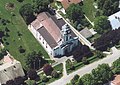 Saint Michael's church, Apátfalva

References
- ^ a b Gazetteer of Hungary, 1st January 2015. Hungarian Central Statistical Office. 3 September 2015
- v
- t
- e
- Hódmezővásárhely
- Szeged (county seat)

- Csanádpalota
- Csongrád
- Kistelek
- Makó
- Mindszent
- Mórahalom
- Sándorfalva
- Szentes
- Algyő
- Ásotthalom
- Kiszombor
- Nagymágocs
- Szegvár
- Ambrózfalva
- Apátfalva
- Árpádhalom
- Baks
- Balástya
- Bordány
- Csanádalberti
- Csanytelek
- Csengele
- Derekegyház
- Deszk
- Domaszék
- Dóc
- Eperjes
- Fábiánsebestyén
- Felgyő
- Ferencszállás
- Forráskút
- Földeák
- Királyhegyes
- Klárafalva
- Kövegy
- Kübekháza
- Magyarcsanád
- Maroslele
- Mártély
- Nagyér
- Nagylak
- Nagytőke
- Óföldeák
- Ópusztaszer
- Öttömös
- Pitvaros
- Pusztamérges
- Pusztaszer
- Röszke
- Ruzsa
- Szatymaz
- Székkutas
- Tiszasziget
- Tömörkény
- Újszentiván
- Üllés
- Zákányszék
- Zsombó
- History
- Geography
- Government
- Economy
- Culture
- Tourism
46°10′N 20°35′E / 46.167°N 20.583°E / 46.167; 20.583
 | This Csongrád-Csanád County location article is a stub. You can help Wikipedia by expanding it. |
- v
- t
- e


 Apátfalva