Branchton railway station
Railway station in Inverclyde, Scotland, UK
55°56′25″N 4°48′15″W / 55.9404°N 4.8042°W / 55.9404; -4.8042
 0.111 million 0.107 million 18,714
 68,962 88,506
Notes | |
|---|---|
Passenger statistics from the Office of Rail and Road |
Branchton railway station is a railway station in Scotland opened in 1967 under British Rail located in the south-west of the town of Greenock, beside the area called Branchton. The station is on the Inverclyde Line, 24+3⁄4 mi (40 km) west of Glasgow Central. The station is managed by ScotRail.
Services
There is an hourly service daily (including Sundays) eastbound to Paisley Gilmour Street & Glasgow Central and westbound to Wemyss Bay on the Inverclyde Line. [1]
| Preceding station | Following station | |||
|---|---|---|---|---|
| Inverkip | ScotRail Inverclyde Line | Drumfrochar | ||
Gallery
-
 The station in 1974
 -
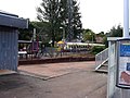
 The station building had been unstaffed and boarded up for several years. It was boarded up shortly after being completely renovated, The station building was demolished in March 2015. Inverkip Road is to the left; Ravenscraig Court is obscured by the trees.
 -
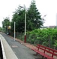 Looking down the platform, away from the station building. The posts with the yellow bands are for new CCTV equipment for use by train drivers.
 -
 Eastbound Class 334 train arriving at the station


Notes
- ^ Table 219 National Rail timetable, May 2016
References
- Butt, R. V. J. (October 1995). The Directory of Railway Stations: details every public and private passenger station, halt, platform and stopping place, past and present (1st ed.). Sparkford: Patrick Stephens Ltd. ISBN 978-1-85260-508-7. OCLC 60251199. OL 11956311M.
- Jowett, Alan (March 1989). Jowett's Railway Atlas of Great Britain and Ireland: From Pre-Grouping to the Present Day (1st ed.). Sparkford: Patrick Stephens Ltd. ISBN 978-1-85260-086-0. OCLC 22311137.
- Yonge, John (May 1987). Gerald Jacobs (ed.). British Rail Track Diagrams - Book 1: ScotRail (1st ed.). Exeter: Quail Map Company. ISBN 0-9006-0948-6.
- Yonge, John (February 1993). Gerald Jacobs (ed.). Railway Track Diagrams - Book 1: Scotland and the Isle of Man (2nd ed.). Exeter: Quail Map Company. ISBN 0-9006-0995-8.
- Yonge, John (April 1996). Gerald Jacobs (ed.). Railway Track Diagrams - Book 1: Scotland and the Isle of Man (3rd ed.). Exeter: Quail Map Company. ISBN 1-8983-1919-7.
- Yonge, John (2007). Gerald Jacobs (ed.). Railway Track Diagrams - Book 1: Scotland & Isle of Man (Quail Track Plans) (fifth ed.). Bradford on Avon: Trackmaps (formerly Quail Map Co). ISBN 978-0-9549866-3-6. OCLC 79435248.
- v
- t
- e
Railway stations served by ScotRail
Stations listed in italics are request stops.
- Alexandra Parade
- Anderston
- Anniesland
- Argyle Street
- Ashfield
- Baillieston
- Barnhill
- Bellgrove
- Blantyre
- Bridgeton
- Burnside
- Cambuslang
- Cardonald
- Carmyle
- Carntyne
- Cathcart
- Charing Cross (Glasgow)
- Corkerhill
- Croftfoot
- Crookston
- Crosshill
- Crossmyloof
- Dalmarnock
- Drumchapel
- Duke Street
- Dumbreck
- Easterhouse
- Exhibition Centre
- Garrowhill
- Garscadden
- Gilshochill
- Glasgow Central
- Glasgow Queen Street
- High Street (Glasgow)
- Hillington East
- Hillington West
- Hyndland
- Jordanhill
- Kelvindale
- Kennishead
- King's Park
- Kirkhill
- Langside
- Maryhill
- Maxwell Park
- Mosspark
- Mount Florida
- Mount Vernon
- Muirend
- Newton
- Nitshill
- Partick
- Pollokshaws East
- Pollokshaws West
- Pollokshields East
- Pollokshields West
- Possilpark & Parkhouse
- Priesthill & Darnley
- Queens Park (Glasgow)
- Robroyston
- Rutherglen
- Scotstounhill
- Shawlands
- Shettleston
- Springburn
- Summerston
- Airbles
- Airdrie
- Bargeddie
- Bellshill
- Blairhill
- Caldercruix
- Camelon
- Carfin
- Chatelherault
- Cleland
- Coatbridge Central
- Coatbridge Sunnyside
- Coatdyke
- Croy
- Cumbernauld
- Drumgelloch
- East Kilbride
- Falkirk Grahamston
- Falkirk High
- Gartcosh
- Greenfaulds
- Hairmyres
- Hamilton Central
- Hamilton West
- Hartwood
- Holytown
- Kirkwood
- Larbert
- Larkhall
- Merryton
- Motherwell
- Polmont
- Shieldmuir
- Shotts
- Stepps
- Thorntonhall
- Uddingston
- Whifflet
- Wishaw
- Addiewell
- Armadale
- Bathgate
- Blackridge
- Breich
- Brunstane
- Curriehill
- Dalmeny
- Edinburgh Gateway
- Edinburgh Park
- Edinburgh Waverley
- Eskbank
- Fauldhouse
- Haymarket
- Kingsknowe
- Kirknewton
- Linlithgow
- Livingston North
- Livingston South
- Musselburgh
- Newcraighall
- Shawfair
- Slateford
- South Gyle
- Uphall
- West Calder
- Wester Hailes
(and England)
- Annan
- Auchinleck
- Ayr
- Barassie
- Barrhill
- Carlisle
- Carluke
- Carstairs
- Drem
- Dumfries
- Dunbar
- Dunlop
- East Linton
- Galashiels
- Girvan
- Gorebridge
- Gretna Green
- Kilmarnock
- Kilmaurs
- Kirkconnel
- Lanark
- Longniddry
- Maybole
- New Cumnock
- Newtongrange
- Newton-on-Ayr
- North Berwick
- Prestonpans
- Prestwick International Airport
- Prestwick Town
- Sanquhar
- Stewarton
- Stow
- Stranraer
- Troon
- Tweedbank
- Wallyford
- Alexandria
- Ardlui
- Ardrossan Harbour
- Ardrossan South Beach
- Ardrossan Town
- Arrochar and Tarbet
- Balloch
- Barrhead
- Bearsden
- Bishopbriggs
- Bishopton
- Bogston
- Bowling
- Branchton
- Busby
- Cardross
- Cartsdyke
- Clarkston
- Clydebank
- Craigendoran
- Dalmuir
- Dalreoch
- Dalry
- Drumfrochar
- Drumry
- Dumbarton Central
- Dumbarton East
- Fairlie
- Fort Matilda
- Garelochhead
- Giffnock
- Glengarnock
- Gourock
- Greenock Central
- Greenock West
- Hawkhead
- Helensburgh Central
- Helensburgh Upper
- Hillfoot
- Howwood
- Inverkip
- Irvine
- Johnstone
- Kilpatrick
- Kilwinning
- Langbank
- Largs
- Lenzie
- Lochwinnoch
- Milliken Park
- Milngavie
- Neilston
- Paisley Canal
- Paisley Gilmour Street
- Paisley St James
- Patterton
- Port Glasgow
- Renton
- Saltcoats
- Singer
- Stevenston
- Thornliebank
- Wemyss Bay
- West Kilbride
- Westerton
- Whinhill
- Whitecraigs
- Williamwood
- Woodhall
- Yoker
- Aberdour
- Alloa
- Blair Atholl
- Bridge of Allan
- Burntisland
- Cameron Bridge
- Cardenden
- Cowdenbeath
- Crianlarich
- Cupar
- Dalgety Bay
- Dunblane
- Dunfermline City
- Dunfermline Queen Margaret
- Dunkeld & Birnam
- Gleneagles
- Glenrothes with Thornton
- Invergowrie
- Inverkeithing
- Kinghorn
- Kirkcaldy
- Ladybank
- Leuchars
- Leven
- Lochgelly
- Markinch
- North Queensferry
- Perth
- Pitlochry
- Rannoch
- Rosyth
- Springfield
- Stirling
- Tyndrum Lower
- Upper Tyndrum
- Achanalt
- Achnasheen
- Achnashellach
- Alness
- Altnabreac
- Ardgay
- Arisaig
- Attadale
- Aviemore
- Banavie
- Beasdale
- Beauly
- Bridge of Orchy
- Brora
- Carrbridge
- Connel Ferry
- Conon Bridge
- Corpach
- Corrour
- Culrain
- Dalmally
- Dalwhinnie
- Dingwall
- Duirinish
- Duncraig
- Dunrobin Castle
- Elgin
- Falls of Cruachan
- Fearn
- Forres
- Forsinard
- Fort William
- Garve
- Georgemas Junction
- Glenfinnan
- Golspie
- Helmsdale
- Invergordon
- Inverness
- Inverness Airport
- Invershin
- Keith
- Kildonan
- Kinbrace
- Kingussie
- Kyle of Lochalsh
- Lairg
- Loch Awe
- Loch Eil Outward Bound
- Lochailort
- Locheilside
- Lochluichart
- Mallaig
- Morar
- Muir of Ord
- Nairn
- Newtonmore
- Oban
- Plockton
- Rogart
- Roy Bridge
- Scotscalder
- Spean Bridge
- Strathcarron
- Stromeferry
- Tain
- Taynuilt
- Thurso
- Tulloch
- Wick
 | This Scotland railway station-related article is a stub. You can help Wikipedia by expanding it. |
- v
- t
- e


