Budkovce
Village and municipality in Slovakia
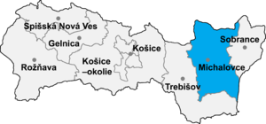
Budkovce (Hungarian: Butka [ˈbutkɒ]) a village and municipality in Michalovce District in the Kosice Region of eastern Slovakia.
History
In historical records the village was first mentioned in 1319. Before the establishment of independent Czechoslovakia in 1918, it was part of Zemplén County within the Kingdom of Hungary.
Geography
The village lies at an altitude of 102 metres and covers an area of 19.83 km2 (7.66 sq mi) (2020-06-30/-07-01).[1]
Ethnicity
The population is almost entirely Slovak in ethnicity.
Population
Its population is 1,508 people (2020-12-31).[2]
Government
The village relies on the tax and district offices, police force and fire brigade at Michalovce although the village has its own birth registry.
Economy
The village has a post office, a Slovak bank and insurance company and a number of food stores.
Sports
The village has a football pitch and a gymnasium.
Genealogical resources
The records for genealogical research are available at the state archive "Statny Archiv in Kosice, Presov, Slovakia"
- Roman Catholic church records (births/marriages/deaths): 1850-1895 (parish A)
- Greek Catholic church records (births/marriages/deaths): 1756-1904 (parish B)
- Reformed church records (births/marriages/deaths): 1793-1938 (parish B)
Gallery
-
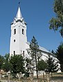 Holy Trinity church (est. 14th century) in Budkovce
 -
 Memorial to the executed victims of the 1831 East Slovak Peasant Uprising
 -
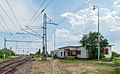 Standard gauge and broad gauge railway and broad gauge freight station in Budkovce


See also
- List of municipalities and towns in Michalovce District
- List of municipalities and towns in Slovakia
References
External links
Wikimedia Commons has media related to Budkovce.
- https://web.archive.org/web/20071217080336/http://www.statistics.sk/mosmis/eng/run.html
- Surnames of living people in Budkovce
- v
- t
- e
Municipalities of Michalovce District
- Bajany
- Bánovce nad Ondavou
- Beša
- Bracovce
- Budince
- Budkovce
- Čečehov
- Čičarovce
- Čierne Pole
- Drahňov
- Dúbravka
- Falkušovce
- Hatalov
- Hažín
- Hnojné
- Horovce
- Iňačovce
- Ižkovce
- Jastrabie pri Michalovciach
- Jovsa
- Kačanov
- Kaluža
- Kapušianske Kľačany
- Klokočov
- Krásnovce
- Krišovská Liesková
- Kusín
- Lastomír
- Laškovce
- Lesné
- Ložín
- Lúčky
- Malčice
- Malé Raškovce
- Markovce
- Maťovské Vojkovce
- Moravany
- Nacina Ves
- Oborín
- Oreské
- Palín
- Pavlovce nad Uhom
- Petrikovce
- Petrovce nad Laborcom
- Poruba pod Vihorlatom
- Pozdišovce
- Ptrukša
- Pusté Čemerné
- Rakovec nad Ondavou
- Ruská
- Senné
- Slavkovce
- Sliepkovce
- Staré
- Stretava
- Stretavka
- Suché
- Šamudovce
- Trhovište
- Trnava pri Laborci
- Tušice
- Tušická Nová Ves
- Veľké Raškovce
- Veľké Slemence
- Vinné
- Vojany
- Voľa
- Vrbnica
- Vysoká nad Uhom
- Zalužice
- Závadka
- Zbudza
- Zemplínska Široká
- Zemplínske Kopčany
- Žbince

Authority control databases | |
|---|---|
| International |
|
| National |
|
48°38′N 21°56′E / 48.633°N 21.933°E / 48.633; 21.933
 | This Michalovce District geography article is a stub. You can help Wikipedia by expanding it. |
- v
- t
- e


