Calumet, Lexington
Place in Kentucky, United States
Calumet | |
|---|---|
Neighborhood of Lexington, Kentucky | |
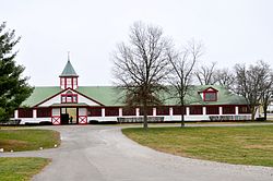 Stables at Calumet Farm | |
| Country | United States |
| State | Kentucky |
| County | Fayette |
| City | Lexington |
| Area | |
| • Total | 0.266 sq mi (0.69 km2) |
| Population (2000) | |
| • Total | 750 |
| • Density | 2,882/sq mi (1,087/km2) |
| Time zone | UTC-5 (Eastern (EST)) |
| • Summer (DST) | UTC-4 (EDT) |
| ZIP code | 40504 |
| Area code | 859 |
Calumet is a neighborhood in northern Lexington, Kentucky, United States. Its boundaries are Viley Road to the west, Versailles Road to the south, New Circle Road to the north, and Wolf Run Creek to the east.[1]
Neighborhood statistics
- Area: 0.266 square miles (0.69 km2)
- Population: 750
- Population density: 2,822 people per square mile (1,090 people/km2)
- Median household income: $49,446[1]
References
- ^ a b Calumet Neighborhood Profile city-data.com. Retrieved on 2011-01-02
- v
- t
- e
Lexington-Fayette
- Cityscape
- Culture
- Demographics
- Economy
- Education
- Geography
- Government
- History
- Major employers
- Media
- Parks
- People
- Public art
- Sports
- Transportation


landmarks
- Alumni Gym Fitness Center
- Ashland
- Aviation Museum of Kentucky
- Bell Soccer Complex
- Calumet Farm
- Central Bank Center
- City Center
- Fayette National Bank Building
- Gratz Park
- Hunt–Morgan House
- Keeneland
- Kentucky Horse Park
- Kentucky Proud Park
- Kentucky Theatre
- Kroger Field
- Lexington Brewing and Distilling Company
- Lexington Cemetery
- Lexington Financial Center
- Lexington History Center
- Counter Clocks Field
- Mary Todd Lincoln House
- McConnell Springs
- Memorial Coliseum
- Mount Horeb Earthworks Complex
- Patterson Office Tower
- Pope Villa
- The Red Mile
- Singletary Center for the Arts
- University of Kentucky Art Museum
- Waveland State Historic Site
universities
- Bluegrass Community and Technical College
- Indiana Wesleyan University-Lexington
- Lexington Theological Seminary
- Midway University-Lexington
- National College–Lexington
- Sullivan University-Lexington
- Transylvania University
- University of Kentucky
- Kentucky Wildcats
- Lexington Legends
- Transylvania Pioneers
- KHSAA Commonwealth Gridiron Bowl
- KHSAA Sweet Sixteen (boys & girls)
38°03′07″N 84°33′22″W / 38.052°N 84.556°W / 38.052; -84.556
 | This Fayette County, Kentucky state location article is a stub. You can help Wikipedia by expanding it. |
- v
- t
- e


 Calumet,_Lexington