Cecil Hoskins Nature Reserve
Protected area in New South Wales, Australia
34°31.942′S 150°23.887′E / 34.532367°S 150.398117°E / -34.532367; 150.398117New South Wales
The Cecil Hoskins Nature Reserve is a protected nature reserve located in the Southern Highlands area of New South Wales, Australia. The 46-hectare (110-acre) reserve is situated between the towns of Bowral and Moss Vale and is known for bird watching.[1]
Description
The nature reserve is a mostly cleared area with a dammed section of the Wingecarribee River. Much of the area was cleared in the 1820s by Charles Throsby. The Throsby Park Historic Site is located near the reserve. There is some remnant bushland with the rare Camden woollybutt and some of the best stands of snow gums in the southern Highlands. Recent plantings have increased the area of natural bushland.
Barbecue, picnic facilities and public toilets are present. The area is more of a cultural reserve than preserved natural bushland.[2]
Etymology
Cecil Hoskins had been a resident at Exeter and Moss Vale and had a keen interest in gardens. He had a profound knowledge of trees and shrubs in particular and his advice on parks and gardens was sought by many. As well as his extensive home gardens at Invergowrie Exeter and later at Cardrona Moss Vale, there is much evidence of his keen interest in creating parks and gardens. For example, he planned the unique garden setting for the Portland Cement Works at Berrima, he was responsible for the planning and development of Seymour Park in Moss Vale and was Chairman of the Berrima District Committee of the Remembrance Driveway.[2]
Fauna
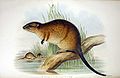
Foxes cause considerable damage to the local wildlife. They have been targeted by shooting, poisoning and trapping. The platypus, water rat and eastern grey kangaroo are recorded here.
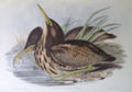
The bird life of the area is of interest. At least 90 species of birds have been recorded. Cecil Hoskins Nature Reserve is an important resting and feeding place for many migratory species, particularly waterbirds. During drought, many inland birds find refuge here. Noteworthy sightings recorded here include the blue-billed duck and the rare Australasian bittern.[2]
Gallery

See also
 New South Wales portal
 environment portal


References
- ^ a b c "Cecil Hoskins Nature Reserve". Office of Environment & Heritage. Government of New South Wales. Retrieved 19 September 2014.
- ^ a b c "Cecil Hoskins Nature Reserve: Plan of Management" (PDF). NSW National Parks & Wildlife Service. Government of New South Wales. May 1999. ISBN 0-7310-7676-1. Retrieved 23 September 2012.
- v
- t
- e
Nature reserves of New South Wales, Australia
- Avisford
- Barton
- Binnaway
- Boronga
- Coolbaggie
- Copperhannia
- Dapper
- Eugowra
- Evans Crown
- Freemantle
- Girralang
- Koorawatha
- Macquarie Marshes
- Munghorn Gap
- Pilliga
- Quanda
- South West Woodland
- Tollingo
- Wambool
- Weetalibah
- Winburndale
- Woggoon
- Wongarbon
- Kajuligah
- Kemendok
- Ledknapper
- Morrisons
- Mutawintji
- Narran Lake
- Nearie Lake
- Nocoleche
- Nombinnie
- Paddington
- Round Hill
- Tarawi
- Yathong
- Awabakal
- Bandicoot Island
- Berrico
- Bird Island
- Boondelbah
- Bretti
- Brimbin Nature Reserve
- Bugan Nature Reserve
- Burning Mountain
- Bushy Island
- Camels Hump
- Camerons Gorge
- Cedar Brush
- Cockle Bay
- Coocumbac Island
- Coolongolook
- Corrie Island
- Coxcomb
- Darawank
- Durands Island
- Flat Island
- Goonook
- John Gould
- Karuah
- Khatambuhl
- Khappinghat
- Killabakh
- Killarney
- Lion Island
- Little Broughton Island
- Manobalai
- Mernot
- Mills Island
- Minimbah
- Moffats Swamp
- Monkerai
- Monkeycot
- Moon Island
- One Tree Island
- Pambalong
- Pelican Island
- Pulbah Island
- Regatta Island
- Rileys Island
- Saratoga Island
- Seaham Swamp
- Seal Rocks
- Snapper Island
- Spectacle Island
- Stormpetrel
- Talawahl
- The Glen
- Tilligerry
- Tingira Heights
- Towibakh
- Wallamba
- Wallis Island
- Wamberal Lagoon
- Wambina
- Watchimbark
- Weelah
- Wingen Maid
- Wingham Brush
- Yahoo Island
- Bamarang
- Barren Grounds
- Barrengarry
- Belowla Island
- Berkeley
- Brundee Swamp
- Brush Island
- Cambewarra Range
- Comerong Island
- Dharawal
- Five Islands
- Kangaroo River
- Narrawallee Creek
- Parma Creek
- Rodway
- Saltwater Swamp
- Tapitallee
- Triplarina
- Wogamia
- Woollamia
- Worrigee
- Yatteyattah
- Aberbaldie
- Arakoola
- Back River
- Bluff River
- Bolivia Hill
- Boomi
- Boomi West
- Booroolong
- Brigalow
- Budelah
- Burral Yurrul
- Captains Creek
- Careunga
- Demon
- Doctors Nose Mountain
- Donnybrook
- Dthinna Dthinnawan
- Duval
- Gamilaroi
- Georges Creek
- Gibraltar
- Guy Fawkes River
- Imbota
- Ironbark
- Jobs Mountain
- Kirramingly
- Linton
- Little Llangothlin
- Mann River
- Melville Range
- Midkin
- Mother Of Ducks Lagoon
- Mount Mackenzie
- Ngulin
- North Obelisk
- Pilliga
- Planchonella
- Serpentine
- Severn River
- Stony Batter Creek
- Taringa
- The Basin
- The Castles
- Tomalla
- Tuggolo Creek
- Wallabadah
- Watsons Creek
- Yina
- Andrew Johnston Big Scrub
- Baalijin
- Bagul Waajaarr
- Ballina
- Banyabba
- Billinudgel
- Boatharbour
- Bollanolla
- Boonanghi
- Boorganna
- Bowraville
- Bridal Veil Falls
- Broken Head
- Brunswick Heads
- Bungabbee
- Bungawalbin
- Burnt-Down Scrub
- Byrnes Scrub
- Chambigne
- Chapmans Peak
- Clarence Estuary
- Cobaki
- Comboyne
- Cook Island
- Cooperabung Creek
- Coramba
- Couchy Creek
- Cudgen
- Cudgera Creek
- Cumbebin Swamp
- Davis Scrub
- Deer Vale
- Duroby
- Fifes Knob
- Fishermans Bend
- Flaggy Creek
- Gads Sugarloaf
- Ganay
- Garby
- Hattons Bluff
- Hayters Hill
- Hogarth Range
- Hortons Creek
- Iluka
- Inner Pocket
- Jaaningga
- Jagun
- Jasper
- Jinangong
- Jobs Mountain
- Julian Rocks Nguthungulli
- Juugawaarri
- Kattang
- Killabakh
- Koorebang
- Kororo
- Koukandowie
- Lake Innes
- Limpinwood
- Little Pimlico Island
- Macquarie
- Marshalls Creek
- Moonee Beach
- Moore Park
- Mororo Creek
- Mount Hyland
- Mount Neville
- Mount Nullum
- Mount Seaview
- Muckleewee Mountain
- Muldiva
- Munro Island
- Muttonbird Island
- Ngambaa
- North Rock
- North Solitary Island
- North-West Solitary Island
- Numinbah
- Pee Dee
- Queens Lake
- Rawdon Creek
- Richmond River
- Sherwood
- Skillion
- Snows Gully
- South West Solitary Island
- Split Solitary Island
- Stotts Island
- Susan Island
- Tabbimoble Swamp
- Tallawudjah
- The Castles
- Tuckean
- Tucki Tucki
- Tweed Estuary
- Tyagarah
- Ukerebagh
- Uralba
- Valla
- Verges Creek
- Victoria Park
- Waragai Creek
- Willi Willi Caves
- Wilson
- Woodford Island
- Wooyung
- Woregore
- Yaegl
- Yarravel
- Yarringully
- Yessabah
- Big Bush
- Bimberi
- Bogandyera
- Boginderra Hills
- Buddigower
- Clarkes Hill
- Cocopara
- Courabyra
- Downfall
- Ellerslie
- Flagstaff Memorial
- Gubbata
- Ingalba
- Jerilderie
- Jingellic
- Lachlan Valley
- Lake Urana
- Langtree
- Loughnan
- Mudjarn
- Mullengandra
- Murrumbidgee Valley
- Nest Hill
- Nombinnie
- Pucawan
- Pulletop
- South West Woodland
- Tabletop
- The Rock
- The Charcoal Tank
- Ulandra
- Wiesners Swamp
- Yanga
- Araluen
- Badja Swamps
- Barunguba Montague Island
- Bees Nest
- Bell Bird Creek
- Bermaguee
- Binjura
- Black Andrew
- Bobundara
- Bondi Gulf
- Bournda
- Broulee Island
- Burnt School
- Burra Creek
- Burrinjuck
- Cecil Hoskins
- Coolumbooka
- Coornartha
- Cullendulla Creek
- Cuumbeun
- Dananbilla
- Dangelong
- Eagles Claw
- Egan Peaks
- Good Good
- Goorooyarroo
- Gungewalla
- Hattons Corner
- Illawong
- Illunie
- Ironmungy
- Jerralong
- Joadja
- Koorawatha
- Kuma
- Kybeyan
- Meringo
- Merriangaah
- Mount Clifford
- Mount Dowling
- Mundoonen
- Myalla
- Nadgee
- Nadgigomar
- Ngadang
- Nimmo
- Numeralla
- Oak Creek
- Paupong
- Queanbeyan
- Quidong
- Razorback
- Robertson
- Scabby Range
- Scott
- Stony Creek
- Strike-a-Light
- Tinderry
- Tollgate Islands
- Turallo
- Undoo
- Wadjan
- Wanna Wanna
- Wee Jasper
- Wollondilly River
- Wullwye
- Yanununbeyan
- Yaouk
- Young
- Agnes Banks
- Castlereagh
- Dalrymple-Hay
- Dural
- Gulguer
- Kemps Creek
- Long Island
- Mulgoa
- Muogamarra
- Newington
- Pitt Town
- Prospect
- Towra Point
- Wallumatta
- Windsor Downs
- Wianamatta


 Cecil_Hoskins_Nature_Reserve