Croker Group
Islands in Northern Territory, Australia
11°06′S 132°42′E / 11.1°S 132.7°E / -11.1; 132.7
Australia
Map all coordinates using OpenStreetMap
Download coordinates as:
- KML
- GPX (all coordinates)
- GPX (primary coordinates)
- GPX (secondary coordinates)
The Croker Group is a group of islands in the Arafura Sea. The group lies offshore from Cobourg Peninsula, and is part of the Northern Territory of Australia. The group is Aboriginal freehold land, held by the Arnhem Land Aboriginal Land Trust.[1]
The group consists of at least 12 named islands, and a number of small unnamed islands and rocks. By far the largest island of the group is Croker Island, which has an area of 331 km2. Croker Island is also the only permanently inhabited island in the group. None of the other islands in the group is larger than 15 km2.
List of Islands
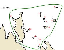
- Croker Island
- Peacock Island
- Oxley Island
- New Year Island
- McCluer Island
- Lawson Island
- Delphinia Island
- Grant Island
- Valencia Island
- Cowlard Island
- Templer Island
- Darch Island
| Name | Area | Location |
|---|---|---|
| Croker Island | 331 km2 | 11°08′00″S 132°33′00″E / 11.1333331°S 132.55°E / -11.1333331; 132.55 (Croker Island) |
| Peacock Island | 0.09 km2[2] | 11°01′30″S 132°27′29″E / 11.025°S 132.458°E / -11.025; 132.458 (Peacock Island) |
| Oxley Island | 2 km2 | 11°00′00″S 132°49′34″E / 11.00°S 132.826°E / -11.00; 132.826 (Oxley Island) |
| New Year Island | 1 km2 | 10°54′29″S 133°01′52″E / 10.908°S 133.031°E / -10.908; 133.031 (New Year Island) |
| McCluer Island | 9 km2 [3] | 11°04′S 133°00′E / 11.07°S 133.0°E / -11.07; 133.0 (McCluer Island) |
| Lawson Island | 3 km2 | 11°03′S 132°52′E / 11.05°S 132.86°E / -11.05; 132.86 (Lawson Island) |
| Delphinia Island | 0.6 km2 | 11°04′56″S 132°52′39″E / 11.0823°S 132.8775°E / -11.0823; 132.8775 (Delphinia Island) |
| Grant Island | 12 km2 | 11°09′22″S 132°53′24″E / 11.156°S 132.89°E / -11.156; 132.89 (Grant Island) |
| Valencia Island | 3 km2 | 11°22′59″S 132°47′06″E / 11.383°S 132.785°E / -11.383; 132.785 (Valencia Island) |
| Cowlard Island | 0.02 km2 | 11°19′00″S 132°47′01″E / 11.31669°S 132.78366°E / -11.31669; 132.78366 (Cowlard Island) |
| Templer Island | 1 km2 | 11°17′21″S 132°43′41″E / 11.28927°S 132.727976°E / -11.28927; 132.727976 (Templer Island) |
| Darch Island | 6 km2 | 11°11′43″S 132°39′45″E / 11.19519°S 132.662578°E / -11.19519; 132.662578 (Darch Island) |
See also
- List of islands of Australia
- NT Place Names Register, McCluer Island named after Captain John McCluer
References
- v
- t
- e
Islands of the Northern Territory
- Bremer
- Burney
- Crocodile
- Milingimbi
- Croker Group
- Croker
- New Year
- East Woody
- Goulburn
- Groote Eylandt
- Bickerton
- Haul Round
- Higginson
- Howard
- Inglis
- Maria
- Peron
- Rimbija
- Sir Edward Pellew
- Centre
- Skull
- Vanderlin
- South West
- Sir George Hope Islands
- Three Hummocks
- Tiwi
- Bathurst
- Melville
- Seagull
- Warnawi
- Wessel
- Abbott
- Bumaga
- Cunningham
- Drysdale
- Elcho
- Marchinbar
- Quail
- Raragala
- Vernon Islands
- Woodah
 Category
 Commons

 | This Northern Territory geography article is a stub. You can help Wikipedia by expanding it. |
- v
- t
- e


 Croker_Group