Grade II* listed buildings in Chesterfield
Map all coordinates using OpenStreetMap
Download coordinates as:
- KML
- GPX (all coordinates)
- GPX (primary coordinates)
- GPX (secondary coordinates)
There are over 20,000 Grade II* listed buildings in England. This page is a list of these buildings in the district of Chesterfield in Derbyshire.
Listed buildings
| Name | Location | Type | Completed [note 1] | Date designated | Grid ref.[note 2] Geo-coordinates | Entry number [note 3] | Image |
|---|---|---|---|---|---|---|---|
| Tapton Grove | Tapton, Brimington | House | c.1800 | 26 September 1977 | SK4013672436 53°14′51″N 1°24′00″W / 53.247431°N 1.399969°W / 53.247431; -1.399969 (Tapton Grove) | 1068875 |  Upload Photo |
| Church of St John the Baptist | Staveley | Church | 13th century and later medieval | 25 February 1966 | SK4335474869 53°16′09″N 1°21′05″W / 53.269047°N 1.351416°W / 53.269047; -1.351416 (Church of St John the Baptist) | 1334670 |  More images |
| The Hagge | Nether Handley, Staveley | Country house | 1630 | 25 February 1966 | SK4119476542 53°17′03″N 1°23′01″W / 53.284256°N 1.383585°W / 53.284256; -1.383585 (The Hagge) | 1205056 | Upload Photo |
| Bank Close (now care home) | Chesterfield | House | Earlier 19th century | 26 September 1977 | SK3880270207 53°13′39″N 1°25′13″W / 53.227495°N 1.420231°W / 53.227495; -1.420231 (Bank Close (now care home)) | 1088274 | Upload Photo |
| Gazebo at Brampton Manor | Brampton | Gazebo | Early 18th century | 13 March 1968 | SK3632071119 53°14′09″N 1°27′26″W / 53.235868°N 1.457304°W / 53.235868; -1.457304 (Gazebo at Brampton Manor) | 1088267 | Upload Photo |
| Mill buildings at Walton Works | Chesterfield | Mill | Late 18th century | 27 September 2004 | SK3677170735 53°13′57″N 1°27′02″W / 53.232385°N 1.450591°W / 53.232385; -1.450591 (Mill buildings at Walton Works) | 1391084 |  |
| Pagets Insurances Ltd and area railings | Chesterfield | Terrace | Late 18th century | 15 July 1971 | SK3818671326 53°14′15″N 1°25′46″W / 53.237598°N 1.429324°W / 53.237598; -1.429324 (Pagets Insurances Ltd and area railings) | 1088238 | 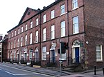 |
| Revolution House | Whittington | House | 17th century | 13 March 1968 | SK3838774957 53°16′13″N 1°25′33″W / 53.27022°N 1.425876°W / 53.27022; -1.425876 (Revolution House) | 1088283 |  More images |
| Roman Catholic Eyre Chapel (behind Newbold Road) | Chesterfield | Chapel | Medieval | 13 March 1968 | SK3687472868 53°15′06″N 1°26′56″W / 53.25155°N 1.448802°W / 53.25155; -1.448802 (Roman Catholic Eyre Chapel (behind Newbold Road)) | 1374497 |  |
| Tapton House | Tapton | House | Late 18th century | 13 March 1968 | SK3921372156 53°14′42″N 1°24′50″W / 53.244983°N 1.413835°W / 53.244983; -1.413835 (Tapton House) | 1088335 |  More images |
| The Gazebo at Somersall Hall | Somersall | Gazebo | Early 17th century | 13 March 1968 | SK3525469967 53°13′32″N 1°28′24″W / 53.225585°N 1.473401°W / 53.225585; -1.473401 (The Gazebo at Somersall Hall) | 1203393 | Upload Photo |
| The Royal Oak Inn | Chesterfield | Public house | 16th century | 15 July 1971 | SK3829471080 53°14′07″N 1°25′40″W / 53.235379°N 1.427735°W / 53.235379; -1.427735 (The Royal Oak Inn) | 1334732 |  More images |
| The Town Pump | Chesterfield | Water pump | Early/mid-19th century | 9 August 1976 | SK3821771100 53°14′08″N 1°25′44″W / 53.235564°N 1.428886°W / 53.235564; -1.428886 (The Town Pump) | 1088256 |  More images |
| Unitarian Chapel | Chesterfield | Chapel | 1694 | 15 July 1971 | SK3832571245 53°14′13″N 1°25′38″W / 53.23686°N 1.427251°W / 53.23686; -1.427251 (Unitarian Chapel) | 1088233 | 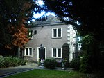 More images |
| 2 St Mary's Gate | Chesterfield | House | Early 17th century | 13 March 1968 | SK3856071205 53°14′11″N 1°25′25″W / 53.236483°N 1.423735°W / 53.236483; -1.423735 (2 St Mary's Gate) | 1025866 |  More images |
| 9 Beetwell Street | Chesterfield | House | Late 16th or early 17th century | 9 August 1976 | SK3835270933 53°14′03″N 1°25′37″W / 53.234053°N 1.426884°W / 53.234053; -1.426884 (9 Beetwell Street) | 1075161 | 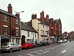 More images |
| 42 St Mary's Gate | Chesterfield | House | Mid-18th century | 4 September 1972 | SK3853271016 53°14′05″N 1°25′27″W / 53.234786°N 1.424177°W / 53.234786; -1.424177 (42 St Mary's Gate) | 1088231 |  More images |
See also
- Grade I listed buildings in Derbyshire
- Grade II* listed buildings in Derbyshire
- Grade II* listed buildings in Amber Valley
- Grade II* listed buildings in Bolsover (district)
- Grade II* listed buildings in Derby
- Grade II* listed buildings in Derbyshire Dales
- Grade II* listed buildings in Erewash
- Grade II* listed buildings in High Peak
- Grade II* listed buildings in North East Derbyshire
- Grade II* listed buildings in South Derbyshire
Notes
- ^ The date given is the date used by Historic England as significant for the initial building or that of an important part in the structure's description.
- ^ Sometimes known as OSGB36, the grid reference is based on the British national grid reference system used by the Ordnance Survey.
- ^ The "List Entry Number" is a unique number assigned to each listed building and scheduled monument by Historic England.
External links
- v
- t
- e
- Bedfordshire
- Berkshire
- Bristol
- Buckinghamshire
- Cambridgeshire
- Cheshire
- Cornwall
- Cumbria
- Derbyshire
- Devon
- Dorset
- Durham
- East Sussex
- East Riding of Yorkshire
- Essex
- Gloucestershire
- Greater London
- Greater Manchester
- Hampshire
- Herefordshire
- Hertfordshire
- Isle of Wight
- Kent
- Lancashire
- Leicestershire
- Lincolnshire
- Merseyside
- Norfolk
- North Yorkshire
- Northamptonshire
- Northumberland
- Nottinghamshire
- Oxfordshire
- Rutland
- Shropshire
- Somerset
- South Yorkshire
- Staffordshire
- Suffolk
- Surrey
- Tyne and Wear
- Warwickshire
- West Midlands
- West Sussex
- West Yorkshire
- Wiltshire
- Worcestershire
- Allerdale
- Amber Valley
- Ashford
- Babergh
- Barrow-in-Furness
- Basildon
- Basingstoke and Deane
- Bath and North East Somerset
- Bolsover
- Boston
- Bournemouth
- Bradford
- Braintree
- Breckland
- Brentwood
- Brighton and Hove
- Bristol
- Broadland
- Calderdale
- Cambridge
- Camden
- Canterbury
- Carlisle
- Castle Point
- Chelmsford
- Cheltenham
- Cherwell
- Cheshire East
- Cheshire West and Chester
- Chesterfield
- Chiltern
- Christchurch
- Colchester
- Copeland
- Corby
- Cotswold
- Dartford
- Daventry
- Dover
- East Cambridgeshire
- Exeter
- Mendip
- North Somerset
- North Yorkshire (district)
- Poole
- Sedgemoor
- South Somerset
- Stoke-on-Trent
- Taunton Deane
- West Somerset
- York


 Grade_II*_listed_buildings_in_Chesterfield