Kosciuszko Road
Road in New South Wales, Australia


East end
West end
- 36°14′49″S 149°03′06″E / 36.246988°S 149.051579°E / -36.246988; 149.051579 (East end)
- 36°25′55″S 148°19′43″E / 36.432049°S 148.328495°E / -36.432049; 148.328495 (West end)
 Snowy Mountains Highway
Pine Valley, New South Wales
- Barry Way
- Alpine Way
Kosciuszko National Park, New South Wales
Kosciuszko Road is a road in the Snowy Mountains of New South Wales, Australia which runs from Pine Valley, to the ski resort of Charlotte Pass in Kosciuszko National Park.
Route
Kosciuszko Road branches from Snowy Mountains Highway in Pine Valley, nearly 7km west of Cooma, and heads roughly westwards, passing through the towns of Berridale and Jindabyne, before crossing Thredbo River and entering Kosciuszko National Park. Within the national park it provides access to Smiggin Holes and Perisher Valley and Charlotte Pass ski resorts, and terminates just past the entry to the latter.
History
The passing of the Main Roads Act of 1924[4] through the Parliament of New South Wales provided for the declaration of Main Roads, roads partially funded by the State government through the Main Roads Board (later Transport for NSW). Main Road No. 286 was declared along this road on 8 August 1928, from the intersection with Monaro Highway (today Snowy Mountains Highway) at Pine Valley via Berriedale and Jindabyne to Mount Kosciuszko;[2] with the passing of the Main Roads (Amendment) Act of 1929[5] to provide for additional declarations of State Highways and Trunk Roads, this was amended to Main Road 286 on 8 April 1929.
The passing of the Roads Act of 1993[6] updated road classifications and the way they could be declared within New South Wales. Under this act, Kosciuszko Road today retains its declaration as Main Road 286, from Pine Valley to Charlotte Pass.[7]
Major intersections
Kosciuszko Road is entirely contained within the Snowy Monaro Regional Council local government area.
| Location | km[1] | mi | Destinations | Notes | |
|---|---|---|---|---|---|
| Pine Valley | 0.0 | 0.0 | Snowy Mountains Highway (B72) – Tumut, Cooma | Eastern terminus of road | |
| Berridale | 25.8 | 16.0 | Myack Street, to Dalgety Road – Dalgety | ||
| Hill Top | 41.1 | 25.5 | Eucumbene Road – Eucumbene | ||
| Snowy River | 51.6 | 32.1 | Jindabyne Dam | ||
| Jindabyne | 55.6 | 34.5 | Barry Way – Suggan Buggan, Buchan | Roundabout | |
| 57.5 | 35.7 | Alpine Way – Khancoban, Corryong | |||
| Thredbo River | 63.2 | 39.3 | Bridge (no known official name) | ||
| Perisher Valley | 86.8 | 53.9 | Perisher Creek Road – Blue Cow | ||
| Charlotte Pass | 94.3 | 58.6 | Charlotte Way – Charlotte Pass | ||
| 95.4 | 59.3 | No through road | Western terminus of road To Mount Kosciuszko Summit via walking track | ||
| |||||
Gallery
-
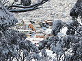 Charlotte Pass Ski Resort from Kosciuszko Road in winter.
 -
 Perisher, Australia's largest ski resort, can be accessed via Kosciuszko Road.
 -
 Statue of Sir Paul Strzelecki in the Snowy Mountains town of Jindabyne.


See also
 Australian Roads portal
References
- ^ a b "Kosciuszko Road" (Map). Google Maps. Retrieved 26 August 2022.
- ^ a b "Main Roads Act, 1924-1927". Government Gazette of the State of New South Wales. No. 110. National Library of Australia. 17 August 1928. pp. 3814–20. Archived from the original on 3 August 2022. Retrieved 1 August 2022.
- ^ "Driving in the snow". NSW Government - Office of Environment and Heritage. 19 July 2011. Retrieved 27 July 2013.
- ^ State of New South Wales, An Act to provide for the better construction, maintenance, and financing of main roads; to provide for developmental roads; to constitute a Main Roads Board Archived 11 August 2022 at the Wayback Machine 10 November 1924
- ^ State of New South Wales, An Act to amend the Main Roads Act, 1924-1927; to confer certain further powers upon the Main Roads Board; to amend the Local Government Act, 1919, and certain other Acts; to validate certain payments and other matters; and for purposes connected therewith. Archived 12 August 2022 at the Wayback Machine 8 April 1929
- ^ State of New South Wales, An Act to make provision with respect to the roads of New South Wales; to repeal the State Roads Act 1986, the Crown and Other Roads Act 1990 and certain other enactments; and for other purposes. Archived 11 August 2022 at the Wayback Machine 10 November 1924
- ^ Transport for NSW (August 2022). "Schedule of Classified Roads and Unclassified Regional Roads" (PDF). Government of New South Wales. Archived from the original (PDF) on 25 August 2022. Retrieved 1 August 2022.
- v
- t
- e
Road infrastructure in regional New South Wales
 Federal Highway
 Hume Highway
 Hunter Expressway
 Pacific Motorway (Brisbane–Brunswick Heads)
- Pacific Motorway (Sydney–Newcastle)
- Princes Motorway


 Appin Road
 Bells Line of Road
 Big River Way
 Bruxner Highway
 Burley Griffin Way
 Castlereagh Highway
 Cobb Highway
 Fossickers Way
 Golden Highway
 Goldfields Way
- Gwydir Highway
 Kamilaroi Highway
 Kidman Way
 Kings Highway
 Lachlan Valley Way
 Memorial Drive
 Monaro Highway
 Oxley Highway
 Picton Road
 Riverina Highway
 Silver City Highway
 Snowy Mountains Highway
- Summerland Way
 Waterfall Way


- Alpine Way
- Barry Way
- Bathurst-Ilford Road
- Bucketts Way
- Bylong Valley Way
- Camden Valley Way
- Carnarvon Highway
- Escort Way
- Giinagay Way
- Goulburn-Oberon Road
- Henry Lawson Way
- Henry Parkes Way
- Irrigation Way
- Jenolan Caves Road
- Kosciuszko Road
- Macleay Valley Way
- Murray Valley Highway
- O'Connell Road
- Old Hume Highway
- Putty Road
- Remembrance Drive
- Solitary Islands Way
- Thunderbolts Way
- Wombeyan Caves Road
- Yass Valley Way
(disused/former)
- Abbotsford
- Balun Bindarray
- Beckers
- Bethanga
- Bland Creek
- Colemans
- Coonamit
- Cooreei
- Crankies Plain
- Dennis
- Dunmore
- The Entrance
- Fitzgearld (Aberdeen)
- Fitzgerald (Raymond Terrace)
- Gee Gee
- George Chaffey
- Glennies
- Goodradigbee
- Grafton
- Harwood
- Hampden (Kangaroo Valley)
- Hay
- Hexham
- Hinton
- Holt-Bragg
- Junction
- Karuah (Monkerai)
- Lennox (Glenbrook)
- MacDonald (St Albans)
- McFarlane
- McKanes Falls
- Macleay Valley
- Martin
- Mooney Mooney
- Morpeth
- Mulwala
- Mungindi
- Murray
- Nowra
- Rip
- Rossi
- Sea Cliff
- Sheahan
- Stockton
- Taemas
- Tea Gardens-Hawks Nest
- Tourle Street
- Towamba
- Vacy
- Victoria (Picton)
- Williams (Clarence Town)
- Wallaby Rocks
- Wollombi (Bulga)
- Yowaka (Greigs Flat)


 Kosciuszko_Road