List of castles in Syria
This is a list of castles in Syria.
Map all coordinates using OpenStreetMap
Download coordinates as:
- KML
- GPX (all coordinates)
- GPX (primary coordinates)
- GPX (secondary coordinates)
Key
| Key | |
| Name | Name of the surviving building, either how it is popularly known in English, its medieval name or its Arabic name |
| Type | Usually the type of castle represented by the predominant surviving fortified remains |
| Date | Usually the dates of the principal building works relating to the surviving remains |
| Condition | An indication as to what remains of the original castle structure |
| Image | Building or site as it currently exists |
| Coordinates | Location of the castle |
| Governorate | Governorate in which the castle is located |
| Notes | Brief description or information of note |
List of castles
| Located under Israeli occupation. |
| Name | Type | Date | Condition | Image | Coordinates | Governorate | Notes |
|---|---|---|---|---|---|---|---|
| Citadel of Aleppo | Castle | 12th–13th centuries | Partially restored |  | 36°11′57″N 37°09′45″E / 36.19917°N 37.16250°E / 36.19917; 37.16250 (Citadel of Aleppo) | Aleppo | Covers an ancient tell with remains dating back to the 3rd millennium BCE. |
| Qal'at Najm | Hilltop castle | 12th–13th centuries | Partially restored |  | 36°33′18″N 38°15′42″E / 36.55500°N 38.26167°E / 36.55500; 38.26167 (Qal'at Najm) | Aleppo | Besieged in 1820 by Ottoman forces after a local warlord had sought refuge in the castle.[1] |
| Citadel of Damascus | Castle | 11th–13th centuries | Partially restored |  | 33°30′42″N 36°18′7″E / 33.51167°N 36.30194°E / 33.51167; 36.30194 (Citadel of Damascus) | Damascus | Part of the Ancient City of Damascus World Heritage Site.[2] |
| Citadel of Bosra | Castle | Partially restored |  | 32°31′04″N 36°28′54″E / 32.51778°N 36.48167°E / 32.51778; 36.48167 (Citadel of Bosra) | Daraa | Built around a Roman theatre. Part of the Ancient City of Bosra World Heritage Site.[3] | |
| Halabiye | Hilltop castle | 6th century | Ruins |  | 35°41′22″N 39°49′08″E / 35.68944°N 39.81889°E / 35.68944; 39.81889 (Halabiye) | Deir ez-Zor | Originally fortified by Queen Zenobia of Palmyra, refortified under the Byzantine Emperor Justinian I and partially re-used after the Muslim conquest of Syria.[4] |
| Qal'at Rahbeh | Hilltop castle | Ruins |  | 35°00′18″N 40°25′24″E / 35.00500°N 40.42333°E / 35.00500; 40.42333 (Qal'at Rahbeh) | Deir ez-Zor | Much of the current structure dates back to its construction by the Ayyubid lord, Shirkuh II, in 1207. | |
| Qal'at Sukkara | Hilltop castle | Ruins |  | 36°25′38″N 40°23′56″E / 36.42722°N 40.39889°E / 36.42722; 40.39889 (Qal'at Sukkara) | Al Hasakah | Located in the Jebel Abd al-Aziz. | |
| Qalʿat Abū Qubais | Hilltop castle | Partially restored |  | 35°14′05.9″N 36°19′50.8″E / 35.234972°N 36.330778°E / 35.234972; 36.330778 (Qalʿat Abū Qubais) | Hama | ||
| Citadel of Hama | Castle | Ruins |  | 35°08′10″N 36°44′58″E / 35.13611°N 36.74944°E / 35.13611; 36.74944 (Citadel of Hama) | Hama | Excavated by a Danish expedition between 1931 and 1938.[5] | |
| Qalaat al-Madiq | Hilltop castle | Residential area |  | 35°25′12″N 36°23′33″E / 35.42000°N 36.39250°E / 35.42000; 36.39250 (Qal'at al-Madiq) | Hama | ||
| Qal'at al-Rahiyya | Castle | Ruins | 35°16′45″N 37°6′30″E / 35.27917°N 37.10833°E / 35.27917; 37.10833 (Qal'at al-Rahiyya) | Hama | The castle dates back to the second millennium BC.[6] | ||
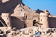
| Masyaf Castle | Spur castle | Partially restored |  | 35°03′58″N 36°20′36″E / 35.06611°N 36.34333°E / 35.06611; 36.34333 (Masyaf Castle) | Hama | ||
| Shaizar | Spur castle | Partially restored |  | 35°15′55″N 36°33′59″E / 35.26528°N 36.56639°E / 35.26528; 36.56639 (Shaizar) | Hama | ||
| Shmemis | Hilltop castle | Ruins |  | 35°02′13″N 37°00′49″E / 35.03694°N 37.01361°E / 35.03694; 37.01361 (Shmemis) | Hama | ||
| Citadel of Homs | Castle | Ruins |  | 34°43′25″N 36°42′52″E / 34.72361°N 36.71444°E / 34.72361; 36.71444 (Citadel of Homs) | Homs | Built on top of an ancient tell with remains dating back to the 3rd millennium BCE.[7] | |
| Fakhr-al-Din al-Maani Castle | Hilltop castle | Partially restored |  | 34°33′46″N 38°15′25″E / 34.56278°N 38.25694°E / 34.56278; 38.25694 (Fakhr-al-Din al-Maani Castle) | Homs | ||
| Qasr al-Hayr al-Gharbi | Desert castle | Ruins | 34°22′28″N 37°36′21″E / 34.37444°N 37.60583°E / 34.37444; 37.60583 (Qasr al-Hayr al-Gharbi) | Homs | |||
| Qasr al-Hayr al-Sharqi | Desert castle | Ruins |  | 35°4′26″N 39°4′16″E / 35.07389°N 39.07111°E / 35.07389; 39.07111 (Qasr al-Hayr al-Sharqi) | Homs | ||
| Krak des Chevaliers | Hilltop castle | Partially restored |  | 34°45′25″N 36°17′4″E / 34.75694°N 36.28444°E / 34.75694; 36.28444 (Krak des Chevaliers) | Homs | Part of the Crac des Chevaliers and Qal'at Salah El-Din World Heritage Site.[8] | |
| Harem Castle | Hilltop castle | Ruins | 36°12′27″N 36°31′09″E / 36.20750°N 36.51917°E / 36.20750; 36.51917 (Harem Castle) | Idlib | |||
| Sarmada | Hilltop castle | Ruins | 36°11′N 36°43′E / 36.183°N 36.717°E / 36.183; 36.717 | Idlib | |||
| Bani Qahtan Castle | Hilltop castle | Ruins | 35°23′44″N 36°09′15″E / 35.39556°N 36.15417°E / 35.39556; 36.15417 (Bani Qahtan Castle) | Latakia | |||
| Bourzey castle | Hilltop castle | Ruins |  | 35°39′29″N 36°15′39″E / 35.65806°N 36.26083°E / 35.65806; 36.26083 (Bourzey Castle) | Latakia | ||
| Mahalibeh Castle | Hilltop castle | Partially restored |  | 35°30′28″N 36°05′14″E / 35.50778°N 36.08722°E / 35.50778; 36.08722 (Mahalibeh Castle) | Latakia | ||
| Qal'at Salah ed-Din | Spur castle | Partially restored |  | 35°35′45″N 36°03′26″E / 35.59583°N 36.05722°E / 35.59583; 36.05722 (Qal'at Salah ed-Din) | Latakia | Part of the Crac des Chevaliers and Qal'at Salah El-Din World Heritage Site.[8] | |
| Nimrod Fortress | Hilltop castle | 13th century |  | 33°15′10″N 35°42′53″E / 33.25278°N 35.71472°E / 33.25278; 35.71472 (Nimrod Fortress) | Quneitra | Located in the Golan Heights | |
| Castle of al-Al | Castle | Quneitra | Located in the Golan Heights | ||||
| Qasr Bardawil | Hilltop castle | 32°49′11.23″N 35°44′32.57″E / 32.8197861°N 35.7423806°E / 32.8197861; 35.7423806 (Nimrod Fortress) | Quneitra | Located in the Golan Heights | |||
| Citadel of Raqqa | Castle | 13th century | Destroyed | 35°56′4″N 39°00′5″E / 35.93444°N 39.00139°E / 35.93444; 39.00139 (Citadel of Raqqa) | Raqqa | The citadel was completely removed and built over in the 1950s.[9] | |
| Qal'at Ja'bar | Hilltop castle | 12th century | Partially restored |  | 35°53′51″N 38°28′51″E / 35.89750°N 38.48083°E / 35.89750; 38.48083 (Qal'at Ja'bar) | Raqqa | Originally situated on a hilltop overlooking the Euphrates Valley but now turned into an island by the flooding of Lake Assad.[10] |
| Jabal Sais | Desert castle/fortification | 7th century | Ruins | 33°16′00″N 37°22′00″E / 33.266667°N 37.366667°E / 33.266667; 37.366667 (Jabal Sais) | Rif Dimashq | The fortification sits near an extinct volcano.[11] | |
| Salkhad Castle | Hilltop castle | Ruins | 32°29′38″N 36°42′36″E / 32.49389°N 36.71000°E / 32.49389; 36.71000 (Salkhad Castle) | Suwayda | |||
| Chastel Blanc | Hilltop castle | Partially restored |  | 34°49′14″N 36°07′01″E / 34.82056°N 36.11694°E / 34.82056; 36.11694 (Chastel Blanc) | Tartus | ||
| Chastel Rouge | Spur castle | Partially restored |  | 34°48′44″N 35°58′14″E / 34.81222°N 35.97056°E / 34.81222; 35.97056 (Chastel Rouge) | Tartus | ||
| Al-Kahf Castle | Spur castle | 12th century | Ruins | 35°02′27″N 36°04′58″E / 35.04083°N 36.08278°E / 35.04083; 36.08278 (Al-Kahf Castle) | Tartus | In 1192, Rashid ad-Din Sinan, also known as the Old Man of the Mountain, died in Al-Kahf Castle, which was an Ismaili stronghold during the 12th century.[12] | |
| Qala'at Khawabi | Spur castle | Residential area |  | 34°58′22″N 36°00′06″E / 34.97278°N 36.00167°E / 34.97278; 36.00167 (Qala'at Khawabi) | Tartus | ||
| Burj al-Sabi | Spur castle | 12th century | Ruins | 35°9′14″N 35°55′38″E / 35.15389°N 35.92722°E / 35.15389; 35.92722 (Burj al-Sabi) | Tartus | Castle of Knights Hospitallers | |
| Areimeh Castle | Spur castle | 12th century | Ruins |  | 34°44′40″N 36°02′33″E / 34.74444°N 36.04250°E / 34.74444; 36.04250 (Areimeh) | Tartus | Castle of Knights Templar |
| Margat | Spur castle | 11th–12th centuries | Partially restored |  | 35°09′08″N 35°57′0″E / 35.15222°N 35.95000°E / 35.15222; 35.95000 (Margat) | Tartus | Headquarters of the Knights Hospitaller in Syria. |
| Maraclea | Hilltop castle | 11th century | Ruins | 35°4′4″N 35°53′26″E / 35.06778°N 35.89056°E / 35.06778; 35.89056 (Maraclea) | Tartus | Castle of Knights Hospitaller | |
| Al-Qadmus Castle | Hilltop castle | 11th–12th centuries | Ruins | 35°6′5″N 36°9′40″E / 35.10139°N 36.16111°E / 35.10139; 36.16111 (Al-Qadmus Castle) | Tartus | Crusader Castle | |
| al-Sheikh Deeb Castle | Hilltop castle | Ruins |  | 34°56′52″N 36°15′30″E / 34.94778°N 36.25833°E / 34.94778; 36.25833 (al-Sheikh Deeb Castle) | Tartus | ||
| Citadel of Tartus | Castle | Residential area |  | 34°53′36″N 35°52′35″E / 34.89333°N 35.87639°E / 34.89333; 35.87639 (Citadel of Tartus) | Tartus |
See also
Wikimedia Commons has media related to Castles in Syria.
References
- ^ Sourdel 2010
- ^ Ancient City of Damascus, UNESCO World Heritage Centre, retrieved 16 March 2011
- ^ Ancient City of Bosra, UNESCO World Heritage Centre, retrieved 23 August 2011
- ^ Burns 2009
- ^ Shaw & Jameson 1999, p. 167
- ^ "Discovery of a 4,000-year-old military network in northern Syria". cnrs.fr. 19 December 2017.
- ^ King 2002, p. 42
- ^ a b Crac des Chevaliers and Qal'at Salah El-Din, UNESCO World Heritage Centre, retrieved 24 August 2011
- ^ Heidemann 2006, p. 122
- ^ Bounni 1977
- ^ Barker, Graeme (1999). Companion Encyclopedia of Archeology Volume 1-2. London: Routledge. p. 1086. Retrieved 13 December 2021.
- ^ Willey 2005, p. 234
Sources
- Bounni, Adnan (1977), "Campaign and exhibition from the Euphrates in Syria", The Annual of the American Schools of Oriental Research, 44: 1–7, JSTOR 3768538
- Burns, R. (2009), The monuments of Syria. A guide, London: I.B. Tauris, pp. 160–161, ISBN 9781845119478
- Heidemann, Stefan (2006), "The Citadel of al-Raqqa and Fortifications in the Middle Euphrates Area", in Kennedy, Hugh (ed.), Muslim Military Architecture in Greater Syria: From the Coming of Islam to the Ottoman Period, History of Warfare, vol. 35, Leiden: Brill, pp. 122–150, ISBN 9004147136
- King, G.R.D. (2002), "Archaeological Fieldwork at the Citadel of Homs, Syria: 1995–1999", Levant, 34: 39–58, doi:10.1179/007589102790217336
- Shaw, Ian; Jameson, Robert (1999), A Dictionary of Archaeology, Oxford: Blackwell, ISBN 978-0631174233
- Sourdel, D. (2010), "Ķalat Nadjm", in Bearman, P.; Bianquis, Th.; Bosworth, C.E.; van Donzel, E.; Heinrichs, W.P. (eds.), Encyclopaedia of Islam, Second Edition, Leiden: Brill Online, OCLC 624382576
- Willey, Peter (2005), Eagle's Nest: Ismaili Castles in Iran and Syria, Institute of Ismaili Studies, I.B.Tauris, ISBN 9781850434641
- v
- t
- e

- Albania
- Armenia
- Austria
- Azerbaijan
- Belarus
- Belgium
- Bosnia and Herzegovina
- Bulgaria
- Croatia
- Cyprus
- Czech Republic
- Denmark
- Estonia
- Finland
- France
- Georgia
- Germany
- Greece
- Hungary
- Ireland
- Isle of Man
- Italy
- Latvia
- Liechtenstein
- Lithuania
- Luxembourg
- Malta
- Netherlands
- North Macedonia
- Norway
- Poland
- Portugal
- Romania
- Russia
- Serbia
- Slovakia
- Slovenia
- Spain
- Sweden
- Switzerland
- Turkey
- Ukraine
- United Kingdom
Castles in Syria | ||
|---|---|---|
|  | |
Also See: Castles in Syria | ||


 List_of_castles_in_Syria