List of potentially active volcanoes in the Philippines
This is a list of potentially active volcanoes in the Philippines, as classified by the Philippine Institute of Volcanology and Seismology.
Map all coordinates using OpenStreetMap
Download coordinates as:
- KML
- GPX (all coordinates)
- GPX (primary coordinates)
- GPX (secondary coordinates)
List
| Name | Elevation (ASL) | Coordinates | Province(s) | Last eruption | |
|---|---|---|---|---|---|
| m | ft | ||||
| Amorong | 376 | 1,234 | 15°49′41″N 120°48′18″E / 15.828°N 120.805°E / 15.828; 120.805 (Amorong) | Pangasinan | Pleistocene |
| Apo | 2,954 | 9,692 | 7°00′29″N 125°16′12″E / 7.008°N 125.27°E / 7.008; 125.27 (Apo) | Cotabato, Davao del Sur | unknown possibly 1640s |
| Arayat | 1,026 | 3,366 | 15°12′00″N 120°44′31″E / 15.20°N 120.742°E / 15.20; 120.742 (Arayat) | Pampanga | Holocene |
| Balatukan | 2,450 | 8,040 | 8°46′N 124°59′E / 8.77°N 124.98°E / 8.77; 124.98 (Balatukan) | Misamis Oriental | Pleistocene |
| Balut | 852 | 2,795 | 5°24′00″N 125°22′30″E / 5.40°N 125.375°E / 5.40; 125.375 (Balut) | Sarangani, Davao Occidental | Holocene |
| Cancajanag | 900 | 3,000 | 10°24′43″N 124°31′55″E / 10.412°N 124.532°E / 10.412; 124.532 (Cancajanag) | Leyte | — |
| Cuernos de Negros | 1,862 | 6,109 | 9°15′29″N 123°10′30″E / 9.258°N 123.175°E / 9.258; 123.175 (Cuernos de Negros) | Negros Oriental | 12,000 BC |
| Dakut | 474 | 1,555 | 5°26′N 120°34′E / 5.44°N 120.56°E / 5.44; 120.56 (Dakut) | Sulu | — |
| Kalatungan | 2,824 | 9,265 | 7°57′N 124°48′E / 7.95°N 124.80°E / 7.95; 124.80 (Kalatungan) | Bukidnon | Holocene |
| Labo | 943 | 3,094 | 14°01′12″N 122°47′31″E / 14.02°N 122.792°E / 14.02; 122.792 (Labo) | Camarines Norte | 27,000 BP |
| Laguna Caldera | 743 | 2,438 | 14°25′N 121°16′E / 14.42°N 121.27°E / 14.42; 121.27 (Laguna Caldera) | Laguna | 28,000 BP |
| Latukan | 2,158 | 7,080 | 7°39′N 124°28′E / 7.65°N 124.47°E / 7.65; 124.47 (Latukan) | Lanao del Sur | Holocene |
| Mahagnao | 800 | 2,600 | 10°52′19″N 124°51′11″E / 10.872°N 124.853°E / 10.872; 124.853 (Mahagnao) | Leyte | — |
| Malinao | 1,548 | 5,079 | 13°25′19″N 123°35′49″E / 13.422°N 123.597°E / 13.422; 123.597 (Malinao) | Albay | 1980[citation needed] |
| Malindig | 1,157 | 3,796 | 13°14′24″N 122°01′05″E / 13.240°N 122.018°E / 13.240; 122.018 (Malindig) | Marinduque | — |
| Mandalagan | 1,879 | 6,165 | 10°39′N 123°15′E / 10.65°N 123.25°E / 10.65; 123.25 (Mandalagan) | Negros Occidental | Holocene |
| Mariveles | 1,388 | 4,554 | 14°31′N 120°28′E / 14.52°N 120.47°E / 14.52; 120.47 (Mariveles) | Bataan | 4000 BP[1] |
| Natib | 1,287 | 4,222 | 14°42′18″N 120°24′00″E / 14.705°N 120.40°E / 14.705; 120.40 (Natib) | Bataan | Holocene |
| Panay | 501 | 1,644 | 13°43′23″N 120°53′35″E / 13.723°N 120.893°E / 13.723; 120.893 (Panay) | Batangas | Pleistocene |
| San Cristobal | 1,470 | 4,820 | 14°04′N 121°26′E / 14.067°N 121.433°E / 14.067; 121.433 (San Cristobal) | Laguna, Quezon | — |
| Santo Tomas | 2,260 | 7,410 | 16°20′N 120°33′E / 16.33°N 120.55°E / 16.33; 120.55 (Santo Tomas Benguet) | Benguet | 1641[citation needed] |
| Silay | 1,535 | 5,036 | 10°46′N 123°14′E / 10.77°N 123.23°E / 10.77; 123.23 (Silay) | Negros Occidental | Holocene |
Gallery
-
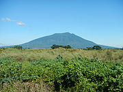 Arayat in Pampanga
 -
 Cuernos de Negros in Negros Island
 -
 Apo in Davao del Sur


See also
- List of active volcanoes in the Philippines
- List of inactive volcanoes in the Philippines
- List of mountains in the Philippines
References
- ^ "Global Volcanism Program | Mariveles".
Sources
- Philippine Institute of Volcanology and Seismology (PHIVOLCS) Potentially Active Volcano list
- Philippine Institute of Volcanology and Seismology (PHIVOLCS) Active Volcano list
- Philippine Institute of Volcanology and Seismology (PHIVOLCS) Inactive Volcano list
External links
- Siebert L, Simkin T (2002–present). Volcanoes of the World: an Illustrated Catalog of Holocene Volcanoes and their Eruptions. Smithsonian Institution, Global Volcanism Program Digital Information Series, GVP-3 (http://www.volcano.si.edu).
- v
- t
- e
Geography of the Philippines

- Archipelagos
- Extreme points
- Headlands
- Hills
- Island groups
- Mountains
- ranges
- passes
- Ultras
- Peninsulas
- Plains
- Valleys
- Volcanoes
Administrative
divisions
divisions
- Climate
- Ecoregions
- Forests
- Landmarks
- Wildlife
- Fauna
- Flora


 List_of_potentially_active_volcanoes_in_the_Philippines