Magliano Sabina
Municipality in Lazio, Italy
Comune in Lazio, Italy
Location of Magliano Sabina

42°22′N 12°29′E / 42.367°N 12.483°E / 42.367; 12.483
[1]
(Dec. 2004)[2]
02046
Magliano Sabina (Local dialect: Majjanu) is a comune (municipality) in the Province of Rieti in the Italian region of Latium, at Tiber Valley, located about 50 kilometres (31 mi) north of Rome and about 30 kilometres (19 mi) west of Rieti. As of 31 December 2004, it had a population of 3,829 and an area of 43.7 square kilometres (16.9 sq mi).[3]
Magliano Sabina borders the following municipalities: Calvi dell'Umbria, Civita Castellana, Collevecchio, Gallese, Montebuono, Orte, Otricoli. Its frazione of Foglia is one of I Borghi più belli d'Italia ("The most beautiful villages of Italy").[4]
The Cathedral is also known as the Concattedrale di San Liberatore Vescovo e Martire.
Demographic evolution

Gallery
-
 The old Felice bridge in 1676
 -
 Inscription in Faliscan language on sandstone, removed from the rock necropolis of Foglia, in the Tiber Valley
 -
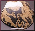 Stamnos red figure ceramic attic vase in the Civic Archaeological Museum of Magliano
 -
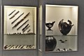
 Archaic iron weapons from the Archaeological Museum of Magliano Sabina
 -
 Iron and bronze repert in the Civic Archaeological Museum of Magliano
 -
 Roman anphore in the Civic Archaeological Museum of Magliano
 -
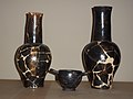 Archaic aphore in the Civic Archaeological Museum of Magliano
 -
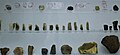 Litic repert, flint scrapers, Archaeological area of Poggio Sommavilla, at Civic Archaeological Museum of Magliano
 -
 Olletta with archaic iscription of Gilio's necropolis, Civic Archaeological Museum of Magliano
 -
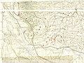 Flaminia Verga, Archaeological map of Tiber Valley, Florence 2006
 -
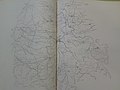 Magliano Sabina in Archaeological map - Falerii e la sua regione rivelata dai sepolcreti, Mancinelli Scotti Francesco


Museum
- Civic archaeological museum of Magliano Sabina [it]
See also
- Foglia (Magliano Sabina)
- Tiber Valley
- Archaeological area of Poggio Sommavilla
References
- ^ "Superficie di Comuni Province e Regioni italiane al 9 ottobre 2011". Italian National Institute of Statistics. Retrieved 16 March 2019.
- ^ "Popolazione Residente al 1° Gennaio 2018". Italian National Institute of Statistics. Retrieved 16 March 2019.
- ^ All demographics and other statistics: Italian statistical institute Istat.
- ^ "Lazio" (in Italian). Retrieved 1 August 2023.
External links
- www.maglianosabina.com/
- v
- t
- e
- Accumoli
- Amatrice
- Antrodoco
- Ascrea
- Belmonte in Sabina
- Borbona
- Borgo Velino
- Borgorose
- Cantalice
- Cantalupo in Sabina
- Casaprota
- Casperia
- Castel Sant'Angelo
- Castel di Tora
- Castelnuovo di Farfa
- Cittaducale
- Cittareale
- Collalto Sabino
- Colle di Tora
- Collegiove
- Collevecchio
- Colli sul Velino
- Concerviano
- Configni
- Contigliano
- Cottanello
- Fara in Sabina
- Fiamignano
- Forano
- Frasso Sabino
- Greccio
- Labro
- Leonessa
- Longone Sabino
- Magliano Sabina
- Marcetelli
- Micigliano
- Mompeo
- Montasola
- Monte San Giovanni in Sabina
- Montebuono
- Monteleone Sabino
- Montenero Sabino
- Montopoli di Sabina
- Morro Reatino
- Nespolo
- Orvinio
- Paganico Sabino
- Pescorocchiano
- Petrella Salto
- Poggio Bustone
- Poggio Catino
- Poggio Mirteto
- Poggio Moiano
- Poggio Nativo
- Poggio San Lorenzo
- Posta
- Pozzaglia Sabina
- Rieti
- Rivodutri
- Rocca Sinibalda
- Roccantica
- Salisano
- Scandriglia
- Selci
- Stimigliano
- Tarano
- Toffia
- Torri in Sabina
- Torricella in Sabina
- Turania
- Vacone
- Varco Sabino
Authority control databases | |
|---|---|
| International |
|
| National |
|
 | This Lazio location article is a stub. You can help Wikipedia by expanding it. |
- v
- t
- e


 Magliano_Sabina