Neptune Islands Conservation Park
Protected area in South Australia
35°16′51″S 136°05′38″E / 35.28083°S 136.09389°E / -35.28083; 136.09389Neptune Islands Conservation Park is a protected area occupying most of the Neptune Islands in South Australia about 55 km (34 mi) south-south east of Port Lincoln. It was established in 1967 principally to protect a New Zealand fur seal breeding colony. The conservation park was subsequently expanded to include the adjoining waters in order to control and manage berleying activities used to attract great white sharks. As of 2002, the conservation park is the only place in Australia where shark cage diving to view great white sharks is legally permitted.
Description
The conservation park includes all the islands within the group with the exception of all or part of the southernmost island (known as Lighthouse Island) in the South Neptune Islands where land has been reserved for ongoing use by a lighthouse and the waters within 2 nautical miles (4 km) of the mean low water mark of both groups of islands.[4][5] The conservation park is classified as an IUCN Category Ia protected area.[1]
History
Part of the island group was proclaimed as a fauna conservation reserve under the Crown Lands Act 1929-1966 on 16 March 1967 mainly to conserve the New Zealand fur seal breeding colony on the southern island of the North Neptune Islands which is reported as being one of the largest in Australia. Other features that contributed to the declaration include the small breeding population of Australian sea lions on the North Neptune Islands, Australian sea lion haul out areas on the South Neptune Islands and the breeding/nesting populations of Cape Barren goose, white-bellied sea eagle, osprey and peregrine falcon.[4][3]
The conservation park was subsequently extended in 1997 to include the waters within 2 nautical miles (4 km) of the shoreline of both the North and South Neptune Islands via a declaration under the National Parks and Wildlife Act 1972 to regulate and manage great white shark berleying activities around both groups of islands.[6]
1n 1990, most of Lighthouse Island was reportedly added to the conservation park after the conversion of the lighthouse to automatic operation with the exception of some land around the lighthouse and an associated helicopter landing site.[7]
On 29 November 2012, the waters within 2 nautical miles (4 km) of the coastline of both the North and South Neptune Islands at median high water also became part of a protected area known as the Neptune Islands Group (Ron and Valerie Taylor) Marine Park.[8][9] The marine park entity provides a level of regulation additional to that of the conservation park in respect to the use of the waters adjoining both groups of islands.[10]
Visitor services
Since 2002, the conservation park is the only venue in Australia where the use of shark cage diving to view great white sharks is legally permitted.[11] Access for shark cage diving is via three operators licensed by the Department of Environment, Water and Natural Resources.[12]
Gallery
Fauna intended to be protected by the declaration of the conservation park in 1967:
-
 New Zealand fur seal
 -
 Australian sea lion
 -
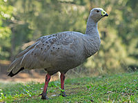 Cape Barren goose
 -
 White-bellied sea eagle
 -
 Osprey
 -
 Peregrine falcon


References
- ^ a b "Terrestrial Protected Areas of South Australia (refer 'DETAIL' tab )". CAPAD 2016. Australian Government, Department of the Environment (DoE). 2016. Retrieved 21 February 2018.
- ^ a b "Protected Areas Information System – reserve list (as of 17 Feb 2014)" (PDF). Department of Environment Water and Natural Resources. p. 5. Retrieved 16 March 2014.
- ^ a b "CROWN LANDS ACT, 1929-1966: FAUNA CONSERVATION RESERVES DEDICATED" (PDF). THE SOUTH AUSTRALIAN GOVERNMENT GAZETTE. Government of South Australia. 16 March 1967. pp. 961–962. Retrieved 5 February 2018.
- ^ a b Baker, J.L (2004). Towards a System of Ecologically Representative Marine Protected Areas in South Australian Marine Bioregions – Technical Report. Part 4 (PDF). Department for Environment and Heritage, South Australia. p. 456.
- ^ "National Parks and Wildlife Act 1972" (PDF). Government of South Australia. p. 87 of 159. Retrieved 22 March 2014.
- ^ "NATIONAL PARKS AND WILDLIFE ACT 1972, SECTION 29 (3): NEPTUNE ISLANDS CONSERVATION PARK, SIR JOSEPH BANKS GROUP CONSERVATION PARK, THE PAGES" (PDF). THE SOUTH AUSTRALIAN GOVERNMENT GAZETT. South Australian government. 24 December 1997. p. 1867. Retrieved 6 February 2018.
- ^ Robinson, A. C.; Canty, P.; Mooney, T.; Rudduck, P. (1996). "South Australia's offshore islands" (PDF). Australian Heritage Commission. pp. 131–132. Retrieved 13 December 2013.
- ^ "Neptune Islands Group Ron and Valerie Taylor Marine Park Management plan summary" (PDF). Department of Environment, Water and Natural Resources. Retrieved 12 March 2013.
- ^ "South Australian Marine Parks take effect today" (PDF). South Australian Government. Archived from the original (PDF) on 24 September 2015. Retrieved 29 November 2012.
- ^ "NEPTUNE ISLANDS GROUP (Ron and Valerie Taylor) MARINE PARK MANAGEMENT PLAN 2012" (PDF). Department of Environment Water and Natural Resources. pp. 5 & 11. Retrieved 13 December 2013.
- ^ Huveneers, C.; Rogers, P.J.; Semmens, J.; Beckmann, C.; Kock, A.A.; Page, B.; Goldsworthy, S.D (2012). Effects of the Shark Shield™ electric deterrent on the behaviour of white sharks (Carcharodon carcharias). Final Report to SafeWork South Australia (PDF). Adelaide: South Australian Research and Development Institute (Aquatic Sciences). p. 15.
- ^ "Shark cage diving". Department of Environment, Water and Natural Resources. Retrieved 22 March 2014.
External links
- Neptune Islands Conservation Park webpage on protected planet
- Neptune Islands Group (Ron and Valerie Taylor) Marine Park
- v
- t
- e
- Adelaide International Bird Sanctuary–Winaityinaityi Pangkara
- Belair
- Canunda
- Cleland
- Coffin Bay
- Coorong
- Dhilba Guuranda-Innes
- Flinders Chase
- Deep Creek
- Glenthorne National Park–Ityamaiitpinna Yarta
- Gawler Ranges
- Great Australian Bight Marine
- Ikara-Flinders Ranges
- Kati Thanda-Lake Eyre
- Lake Frome
- Lake Gairdner
- Lake Torrens
- Lincoln
- Malkumba-Coongie
- Mount Remarkable
- Munga-Thirri–Simpson Desert
- Murray River
- Naracoorte Caves
- Nullarbor
- Nilpena Ediacara
- Onkaparinga River
- Vulkathunha-Gammon Ranges
- Wapma Thura–Southern Flinders Ranges
- Witjira
- Aberdour
- Acraman Creek
- Aldinga Scrub
- Althorpe Islands
- Angove
- Avoid Bay Islands
- Baird Bay Islands
- Bakara
- Bandon
- Bangham
- Barwell
- Bascombe Well
- Baudin
- Baudin Rocks
- Beachport
- Beatrice Islet
- Belt Hill
- Beyeria
- Big Heath
- Billiatt
- Bimbowrie
- Bird Islands
- Black Hill
- Black Rock
- Boondina
- Breakaways
- Brookfield
- Bullock Hill
- Busby Islet
- Butchers Gap
- Calectasia
- Calpatanna Waterhole
- Cap Island
- Cape Blanche
- Cape Gantheaume
- Cape Willoughby
- Caralue Bluff
- Carappee Hill
- Carcuma
- Caroona Creek
- Carpenter Rocks
- Carribie
- Chadinga
- Charleston
- Christmas Rocks
- Clements Gap
- Clinton
- Cocata
- Cooltong
- Corrobinnie Hill
- Cox Scrub
- Cromer
- Cudlee Creek
- Custon
- Cygnet Estuary
- Danggali
- Darke Range
- Desert Camp
- Dingley Dell
- Douglas Point
- Dudley
- Eba Island
- Elliot Price
- Eric Bonython
- Ettrick
- Ewens Ponds
- Fairview
- Ferguson
- Ferries-McDonald
- Finniss
- Fort Glanville
- Fowlers Bay
- Franklin Harbor
- Furner
- Gambier Islands
- Gawler Ranges
- Geegeela
- Giles
- Glen Roy
- Goose Island
- Gower
- Grass Tree
- Greenly Island
- Guichen Bay
- Gum Lagoon
- Gum Tree Gully
- Hacks Lagoon
- Hale
- Hallett Cove
- Hanson Scrub
- Heggaton
- Hesperilla
- Hincks
- Hogwash Bend
- Hopkins Creek
- Horsnell Gully
- Ironstone Hill
- Jip Jip
- Kaiserstuhl
- Kapunda Island
- Karte
- Kathai
- Kellidie Bay
- Kelly Hill
- Kelvin Powrie
- Kenneth Stirling
- Kinchina
- Kulliparu
- Kungari
- Kyeema
- Lake Frome
- Lake Gilles
- Lake Hawdon South
- Lake Newland
- Lake St Clair
- Lashmar
- Lathami
- Laura Bay
- Lawari
- Lesuer
- Leven Beach
- Lincoln
- Lipson Island
- Little Dip
- Lowan
- Lower Glenelg River
- Maize Island Lagoon
- Malgra
- Mamungari
- Mantung
- Marino
- Mark Oliphant
- Marne Valley
- Martin Washpool
- Martindale Hall
- Mary Seymour
- Media Island
- Messent
- Middlecamp Hills
- Mimbara
- Minlacowie
- Moana Sands
- Mokota
- Monarto
- Monarto Woodlands
- Montacute
- Moody Tank
- Morgan
- Morialta
- Mount Billy
- Mount Boothby
- Mount Brown
- Mount Dutton Bay
- Mount George
- Mount Magnificent
- Mount Monster
- Mount Scott
- Mount Taylor
- Mowantjie Willauwar
- Mullinger Swamp
- Munyaroo
- Murrunatta
- Mylor
- Myponga
- Nene Valley
- Nepean Bay
- Neptune Islands
- Newland Head
- Ngarkat
- Ngaut Ngaut
- Nicolas Baudin Island
- Nixon-Skinner
- Nuyts Archipelago
- Nuyts Reef
- Olive Island
- Padthaway
- Pandappa
- Para Wirra
- Paranki Lagoon
- Parndana
- Peachna
- Peebinga
- Pelican Lagoon
- Penambol
- Penguin Island
- Penola
- Piccaninnie Ponds
- Pigface Island
- Pike River
- Pine Hill Soak
- Pinkawillinie
- Point Bell
- Point Davenport
- Point Labatt
- Pooginook
- Poonthie Ruwe
- Porter Scrub
- Pualco Range
- Pullen Island
- Pureba
- Ramco Point
- Ramsay
- Red Banks
- Reedy Creek
- Ridley
- Rilli Island
- Rocky Island (North)
- Rocky Island (South)
- Roonka
- Rudall
- Salt Lagoon Islands
- Sandy Creek
- Sceale Bay
- Scott
- Scott Creek
- Seal Bay
- Searcy Bay
- Seddon
- Shannon
- Sheoak Hill
- Simpson
- Sinclair Island
- Sir Joseph Banks Group
- Sleaford Mere
- Spring Gully
- Spring Mount
- Stipiturus
- Swan Reach
- Talapar
- Talisker
- Tallaringa
- Tantanoola Caves
- Telford Scrub
- The Dutchmans Stern
- The Knoll
- The Pages
- The Plug Range
- Thidna
- Tilley Swamp
- Torrens Island
- Troubridge Island
- Tucknott Scrub
- Tumby Island
- Venus Bay
- Verran Tanks
- Vivigani Ardune
- Vivonne Bay
- Wabma Kadarbu Mound Springs
- Wahgunyah
- Waitpinga
- Waldegrave Islands
- Wanilla
- Wanilla Land Settlement
- Warren
- Warrenben
- West Island
- Wharminda
- Whidbey Isles
- White Dam
- Whyalla
- Wiljani
- Wills Creek
- Winninowie
- Wittelbee
- Woakwine
- Wolseley Common
- Yalpara
- Yeldulknie
- Yulte
- Yumbarra
- Marine protected areas of South Australia
- List of protected areas in Adelaide


 Neptune_Islands_Conservation_Park