Ohio Key
Island in the lower Florida Keys, United States
24°40′19″N 81°14′49″W / 24.672°N 81.247°W / 24.672; -81.247
 United States
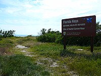
US 1 (or the Overseas Highway) crosses the Ohio Key at approximately mile marker 39, between Missouri Key and Bahia Honda Key. Today it is also known as Sunshine Key,[1] after a camping resort located there. The portion of the island south of U.S. Route 1 is protected as the Ohio Key National Wildlife Refuge.

Former name
It was once known as Little Duck Key, however the name Little Duck Key is currently used for a very small island about a mile (1.6 km) to the east that is the western terminus of the Seven Mile Bridge.
Flora and fauna
The oceanside area of Ohio Key has palm trees, buttonwood trees and mangrove trees, and bird watching occurs there.[2]
References
- ^ McCarthy, K.M. (1992). The Book Lover's Guide to Florida. Pineapple Press. p. 264. ISBN 978-1-56164-012-6. Retrieved September 7, 2017.
- ^ Gray, J. (2015). Insiders' Guide to Florida Keys & Key West. Insiders' Guide Series. Globe Pequot Press. p. 119. ISBN 978-1-4930-1554-2. Retrieved September 7, 2017.
- v
- t
- e
Florida Keys
- Pigeon
- Money
- Little Duck
- Missouri
- Ohio
- Sunshine
- Bahia Honda
- Spanish Harbor
- Scout (West Summerland)
- No Name
- Big Pine
- Torch
- Ramrod
- Summerland
- Knockemdown
- Cudjoe
- Sugarloaf
- Park
- Lower Sugarloaf
- Saddlebunch
- Shark
- Geiger
- Big Coppitt
- East Rockland
- Rockland
- Boca Chica
- Raccoon
- Stock Island
- Key West
- Sigsbee
- Fleming
- Sunset
- Wisteria
- Florida Bay
- Dry Tortugas National Park
- Florida Keys National Marine Sanctuary
- National Key Deer Refuge
- John Pennekamp Coral Reef State Park
- Biscayne Bay
- Biscayne National Park
- Key West National Wildlife Refuge
- Great White Heron National Wildlife Refuge
- Crocodile Lake National Wildlife Refuge
- Florida Reef
 | This Monroe County, Florida location article is a stub. You can help Wikipedia by expanding it. |
- v
- t
- e


 Ohio_Key