Opalescent River
River tributary in New York, United States
| Opalescent River | |
|---|---|
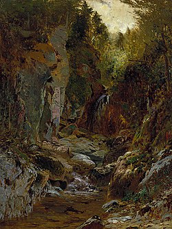 Painting of a flume in the Opalescent River by Alexander H. Wyant | |
| Location | |
| Country | United States |
| State | New York |
| Region | Adirondacks |
| County | Essex |
| Physical characteristics | |
| Source | Little Marcy Mountain |
| • location | Adirondack Mountains, New York, United States |
| • elevation | 4,200 ft (1,300 m) |
| Mouth | |
• coordinates | 44°01′05″N 74°03′10″W / 44.0181°N 74.0528°W / 44.0181; -74.0528 |
The Opalescent River is a river in Essex County, New York. It is both a tributary of and the longest source of the Hudson River. Part of the river is designated by New York State as a Wild River in the Wild, Scenic, and Recreational Rivers system.[1]
Course
Opalescent River has its source on the west side of Little Marcy Mountain, at over 4,200 ft (1,300 m) in elevation.[2] After nearly two miles, Feldspar Brook—which itself originates from Lake Tear of the Clouds—converges with the Opalescent. The river then passes through Flowed Lands, and 11 miles later reaches Calamity Brook, at which point the stream becomes cartographically known as the Hudson River.
The 11-mile stretch from Flowed Lands to the confluence with the Hudson River is designated a New York State Wild River by the New York State Department of Environmental Conservation (DEC).[1]
History
In the 1800s, David Henderson, the owner of an iron vein, thought to dam the Opalescent River to run water past his blast furnaces.[2] The dam was eventually built, but only after Henderson died in a gunshot accident while scouting locations for the dam. The dam diverted water to Calamity Brook (named after the aforementioned accident) until 1984, when it was broken by the DEC over safety concerns.[3]
In 2015, the DEC purchased the 6,200 acre MacIntyre East Tract (which contains seven miles of the lower part of Opalescent River) from The Nature Conservancy for $4.2 million.[4] This acquisition gave more access to visitors for wilderness paddling, as well as opening up the shores to picnicking, fishing, and camping.[5][6]
In 2018, the DEC proposed the creation of three parking areas along the upper Hudson River with put-ins and take-outs for paddlers, including one near the confluence of the Opalescent River and the Hudson River.[7]
References
- ^ a b "Wild, Scenic and Recreational Rivers - NYS Dept. of Environmental Conservation". www.dec.ny.gov. Retrieved 2020-12-13.
- ^ a b "Finding the Sources of the Hudson near Upper Works". Adirondack Hub. 2015-04-23. Retrieved 2020-12-13.
- ^ "A History of the McIntyre Mine". www.adirondack-park.net. Retrieved 2020-12-13.
- ^ "Governor Cuomo Announces 6,200-Acre Acquisition of Former Finch Pruyn Lands". Governor Andrew M. Cuomo. 2015-04-23. Retrieved 2020-12-13.
- ^ Mann, Brian; Newcomb, in; NY. "Paddling the Adirondack Park's wild Opalescent River". NCPR. Retrieved 2020-12-13.
- ^ "State purchase opens up Opalescent". Adirondack Explorer. Retrieved 2020-12-13.
- ^ "DEC proposes put-ins and take-outs along upper Hudson". Adirondack Explorer. Retrieved 2020-12-13.
- v
- t
- e
Hudson River watershed
- Batavia Kill
- Batten Kill
- Birch Creek
- Black Meadow Creek
- Boreas River
- Bowery Creek
- Bowmans Creek
- Breakneck Brook
- Brimstone Creek
- Canajoharie Creek
- Caroga Creek
- Casperkill
- Catskill Creek
- Cayadutta Creek
- Cedar River
- Claverack Creek
- Clove Brook
- Cobleskill Creek
- Coeymans Creek
- Coxsackie Creek
- Cross River
- Croton River
- East Branch Croton River
- East Branch Sacandaga River
- East Canada Creek
- East Kill
- Eightmile Creek
- Esopus Creek
- Fall Kill
- Fishkill Creek
- Fonteyn Kill
- Fulmer Creek
- Hannacrois Creek
- Honnedaga Brook
- Hoosic River
- Indian River
- Jackson Creek
- Jan De Bakkers Kill
- Kaaterskill Creek
- Kayaderosseras
- Kinderhook Creek
- Kisco River
- Lake Creek
- Little Shawangunk Kill
- Maritje Kill
- Miami River
- Mill Creek
- Mohawk River
- Moodna Creek
- Moordener Kill
- Moyer Creek
- Muddy Kill
- Neepaulakating Creek
- Normans Kill
- Nowadaga Creek
- Ohisa Creek
- Onesquethaw Creek
- Opalescent River
- Oriskany Creek
- Otsquago Creek
- Otter Kill
- Papakating Creek
- Peekskill Hollow Creek
- Plattekill Creek
- Platter Kill
- Pocantico River
- Pochuck Creek
- Poesten Kill
- Potic Creek
- Quassaick Creek
- Roeliff Jansen Kill
- Rondout Creek
- Sacandaga River
- Sauquoit Creek
- Saw Kill
- Saw Mill River
- Sawyer Kill
- Schoharie Creek
- Schroon River
- Shawangunk Kill
- Sparkill Creek
- Sprout Creek
- Steele Creek
- Stockport Creek
- Stony Clove Creek
- Taghkanic Creek
- Tenmile Creek
- Tin Brook
- Titicus River
- Trout Brook
- Verkeerder Kill
- Vloman Kill
- Wallkill River
- Walloomsac River
- Wappinger Creek
- Wawayanda Creek
- West Branch Papakating Creek
- West Branch Sacandaga River
- West Canada Creek
- West Kill
- Wynants Kill
- Alcove Reservoir
- Ashokan Reservoir
- Basic Creek Reservoir
- Beacon Reservoir
- Bog Brook Reservoir
- Cedar Lake
- Chadwick Lake
- Chub Lake
- Cross River Reservoir
- Croton Falls Reservoir
- Dyken Pond
- East Branch Reservoir
- East Caroga Lake
- Fall Lake
- Franklinton Vlaie
- Garnet Lake
- Glenmere Lake
- Great Sacandaga Lake
- Great Vlaie
- Henderson Lake
- Honnedaga Lake
- Indian Lake
- Lizard Pond
- Lake Maratanza
- Muscoot Reservoir
- Lake Neepaulin
- New Croton Reservoir
- Notch Lake
- Piseco Lake
- Lake Pleasant
- Queechy Lake
- Rondout Reservoir
- Sacandaga Lake
- Saratoga Lake
- Sturgeon Pool
- Surprise Lake
- Sylvan Lake
- Lake Tear of the Clouds
- Thompson Pond
- Titicus Reservoir
- Trout Lake
- West Caroga Lake
- Whaley Lake
- Winnisook Lake
| New York |
|
|---|---|
| New Jersey |
- Adirondack Mountains
- Adirondack Park
- Ashokan Bridge
- Blenheim Bridge
- Buskirk Bridge
- Catskill Mountains
- Champlain Canal
- Cohoes Falls
- Copeland Bridge
- Delaware and Hudson Canal
- Eagleville Bridge
- East River
- Erie Canal
- George Washington Bridge
- Harlem River
- Helderberg Escarpment
- Holland Tunnel
- Hudson Highlands State Park
- Kaaterskill Clove
- Kaaterskill Falls
- Kill Van Kull
- Kingston–Rhinecliff Bridge
- Lincoln Tunnel
- Mid-Hudson Bridge
- Newburgh–Beacon Bridge
- Tappan Zee Bridge (2017–present)
- The Palisades
- Perrine's Bridge
- Plotter Kill Preserve
- Pollepel Island
- Popolopen
- Rexleigh Bridge
- Rip Van Winkle Bridge
- Salisbury Center Bridge
- Schoharie Bridge
- Shushan Bridge
- Statue of Liberty
- Taconic Mountains
- Verkeerder Kill Falls
- Walkway over the Hudson
- Wallkill River National Wildlife Refuge
- West Canada Lake Wilderness Area


