Rara Lake
Lake in Nepal
29°31′45″N 82°5′35″E / 29.52917°N 82.09306°E / 29.52917; 82.09306
Ramsar Wetland
Rara Lake, also known as Mahendra Lake, is the largest fresh water lake in the Nepalese Himalayas. It is the main feature of Rara National Park, located in Jumla and Mugu Districts of Karnali Province.[1] Rara National Park stretches over 106 km2 (41 sq mi).[3]
History
Rara Lake was included as part of Rara National Park in 1976.[1] In 1976, citizens of the two villages Chapra and Rara were resettled to Nepalgunj.[4] In September 2007, it was declared as a Ramsar site, covering 1,583 ha (6.11 sq mi) including the surrounding wetland.[5] Currently, this area along with the national park is being protected by the Nepali Army.[6]
Features
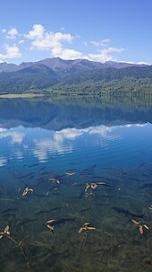
Rara Lake lies at an elevation of 2,975 m (9,760 ft), has a water surface of 10.8 km2 (4.2 sq mi), a maximum depth of 167 m (548 ft), is 5.1 km (3.2 mi) long and 2.7 km (1.7 mi) wide. It drains into the Mugu Karnali River via the Nijar River.[7] The lake changes its colour up to 5 times a day depending on the climate.[8][9][10] Rara Lake is surrounded by thickly forested hills named Chuchemara Danda at 4,087 m (13,409 ft) and Murma at 3,630 m (11,910 ft). Behind the hills, the beautiful view of Saipal Mountain of Himalayan Range can be seen from the lake. One revolution of the lake by foot takes almost five hours.[6] During, summer season, birds as far as Siberia can be found migrating to this area.[11]
Socio-cultural and religious values

The main occupation of the people living around the area is agriculture. People also rear goats and extract medicinal herbs and sell them for their living. Thakur society is dominant in the community. Thakur Baba’s Temple is situated in the southeast corner of the lake. Local people believe that the god Thakur shot an arrow to open the passage of the lake reducing the damage caused by flooding.[7]
Flora and fauna
Rara Lake, being surrounded by Rara National Park, has unique floral and faunal importance with rare and vulnerable species. The park was established in 1976 to preserve the beauty of the lake and protect it from sedimentation and adverse human activities. The Park flora consists of 1074 species, of which 16 are endemic to Nepal; the fauna includes 51 species of mammals and 214 species of birds.[12] The hills surrounding the lake is covered with coniferous forest like Himalayan cypress, West Himalayan Spruce, Black Juniper and Oak. The national flower of the country Rhododendron also occurs here.[citation needed]
The lake holds three endemic fish species Nepalese snowtrout Nepalese snowtrout (Schizothorax macrophthalmus), (S. nepalensis) and the Rara snowtrout (S. raraensis) and one endemic frog, Rara Lake frog (Nanorana rarica). The Rara snowtrout is only recorded in this lake.[13] 236 different species of birds can be found in the lake.[11]
Climate


Rara Lake in winter
Summer is quite pleasant but winter is cold. The best visiting time to the lake is September/October and April to May. From December to March, the temperatures go low below the freezing point, and heavy snowfall occur up to one meter, blocking the way to the lake. April to June is warm in this region.[14]
| Climate data for Rara Lake, elevation 3,048 m (10,000 ft) | |||||||||||||
|---|---|---|---|---|---|---|---|---|---|---|---|---|---|
| Month | Jan | Feb | Mar | Apr | May | Jun | Jul | Aug | Sep | Oct | Nov | Dec | Year |
| Mean daily maximum °C (°F) | 7.6 (45.7) | 9.3 (48.7) | 13.6 (56.5) | 18.9 (66.0) | 21.0 (69.8) | 21.6 (70.9) | 18.8 (65.8) | 18.6 (65.5) | 18.1 (64.6) | 15.9 (60.6) | 10.2 (50.4) | 8.0 (46.4) | 15.1 (59.2) |
| Mean daily minimum °C (°F) | −2.5 (27.5) | −1.5 (29.3) | 2.9 (37.2) | 3.7 (38.7) | 6.0 (42.8) | 9.5 (49.1) | 10.3 (50.5) | 10.2 (50.4) | 8.5 (47.3) | 4.0 (39.2) | 0.2 (32.4) | −1.5 (29.3) | 4.2 (39.5) |
| Average precipitation mm (inches) | 31.4 (1.24) | 42.7 (1.68) | 49.7 (1.96) | 43.3 (1.70) | 69.5 (2.74) | 81.8 (3.22) | 192.4 (7.57) | 207.6 (8.17) | 106.1 (4.18) | 30.1 (1.19) | 8.5 (0.33) | 22.0 (0.87) | 885.1 (34.85) |
| Source 1: Australian National University[15] | |||||||||||||
| Source 2: Japan International Cooperation Agency (precipitation)[16] | |||||||||||||
Transport

Rara Lake does not have connection to the national road network and can only be reached from the nearest town Jumla by trekking. From Nepalgunj there is two ways to reach the lake, one is by following the salt route to Humla and another following a number of trails through Dolpo region. The nearest airports are Talcha Airport in Mugu and Jumla Airport in Jumla.[10] A public bus also runs from Surkhet to Mugu District headquarter Gamgadhi.[17]
Environmental issues
Due to over-grazing and defecation, the national park conservation officers are facing a challenge to preserve the lake. Local people are found cutting timber wood and fuel wood, which is a problem for conservation of Rara. Also during festivals visitors and local people produce a lot of wastage causing water pollution.[7]
See also
Wikimedia Commons has media related to Rara Lake.
 Nepal portal

References
- ^ a b c d e f Bhuju, U. R.; Shakya, P. R.; Basnet, T. B. & Shrestha, S. (2007). Nepal Biodiversity Resource Book. Protected Areas, Ramsar Sites, and World Heritage Sites (PDF). Kathmandu: International Centre for Integrated Mountain Development, Ministry of Environment, Science and Technology, in cooperation with United Nations Environment Programme, Regional Office for Asia and the Pacific. ISBN 978-92-9115-033-5.
- ^ "Rara Lake". Ramsar Sites Information Service. Retrieved 25 April 2018.
- ^ "Rara". Protected Planet. Retrieved 5 January 2022.
- ^ "Rara Lake". Land Nepal. 2021-07-16. Retrieved 2022-07-20.
- ^ Bhandari, B. B. (2009). "Wise use of Wetlands in Nepal". Banko Janakari. 19 (3): 10–17.
- ^ a b Thapa, B. "Rara or Water Nymph! (Photo feature)". Online Khabar (in Nepali). Retrieved 2022-07-21.
- ^ a b c Upadhyay, S.; Chalise, L. & Paudel, R. P. (2009). "High Altitude Ramsar Sites of Nepal". The Initiation: 135–148.
- ^ "Rara: A piece of heaven on the Earth - Tourismmail.com". www.tourismmail.com. Retrieved 2022-07-20.
- ^ "Rara Lake". Land Nepal. 2021. Retrieved 2022-07-20.
- ^ a b आरके अदिप्त गिरी. "रारा की अप्सरा ! ( फोटो फिचर)". Annapurna Post (in Nepali). Retrieved 2022-07-21.
- ^ a b abc (2018). "Rara, the Apsara of Heaven (With Video)". ABC NEWS NEPAL (in Nepali). Retrieved 2022-07-21.
- ^ Rara National Park.(n.d.). Retrieved from http://icimod.org/hkhconservationportal/PA.aspx?ID=64
- ^ "Schizothorax raraensis". www.fishbase.se. Retrieved 2022-07-21.
- ^ "Rara National Park".
- ^ "CLIMATES OF NEPAL AND THEIR IMPLICATIONS FOR AGRICULTURAL DEVELOPMENT" (PDF). Australian National University. Archived from the original (PDF) on 23 October 2023. Retrieved 6 June 2024.
- ^ "ネパール国 全国貯水式水力発電所マスタープラン調査 ファイナルレポート" (PDF). Japan International Cooperation Agency. Archived from the original (PDF) on 6 April 2024. Retrieved 6 June 2024.
- ^ Niraula, Sujan. "Rara or Apsara...? (Photo feature)". Online Khabar (in Nepali). Retrieved 2022-07-21.
External links
- www.rara-lake.com
- Trek to Rara Laka - Details and Photo Feature
- Flickr : Rara Lake
- v
- t
- e
Hydrography of Nepal
| Mahananda basin | |
|---|---|
| Sapta Koshi basin | |
| Bagmati basin | |
| Narayani basin | |
| Karnali basin |
- Nepal portal
Authority control databases | |
|---|---|
| International |
|
| National |
|


