Segreganset River
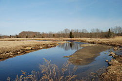
The Segreganset River is a small river in Bristol County, Massachusetts that flows 9.6 miles (15.4 km)[1] in a southeasterly direction through Taunton and Dighton into the Taunton River.[2] Named tributaries include the Maple Swamp, Poppasquash Swamp, Sunken Brook and Cedar Swamp.
The USGS maintains a gaging station on the Segreganset River near Center Street in Dighton.[3]
See also
- Cole River
- Taunton River Watershed
- Three Mile River
References
- v
- t
- e
Taunton River Watershed
- Assonet River
- Canoe River
- Cedar Swamp River
- Cocasset River
- Cotley River
- Forge River
- Hockomock River
- Lady Slipper Brook
- Matfield River
- Mill River
- Nemasket River
- Poor Meadow Brook
- Quequechan River
- Rumford River
- Salisbury Plain River
- Satucket River
- Segreganset River
- Shumatuscacant River
- Snake River
- Taunton River
- Three Mile River
- Town River
- Wading River
- Winnetuxet River
- Assawompset Pond
- Assonet Bay
- Great Quittacas Pond
- Little Quittacas Pond
- Lake Nippenicket
- Norton Reservoir
- Lake Mirimichi
- Lake Rico
- Lake Sabbatia
- Leach Pond
- Long Pond
- Pocksha Pond
- Somerset Reservoir
- Turnpike Lake
- Watson Pond
- Winnecunnet Pond
41°49′30″N 71°07′08″W / 41.825°N 71.119°W / 41.825; -71.119
 | This Bristol County, Massachusetts geography–related article is a stub. You can help Wikipedia by expanding it. |
- v
- t
- e
This article related to a river in Massachusetts is a stub. You can help Wikipedia by expanding it. |
- v
- t
- e


 Segreganset_River