Sierra Madre del Sur
Mountain range in southern Mexico
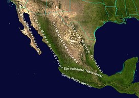
Sierra Madre del Sur, other major mountain ranges, and the Mexican Plateau
The Sierra Madre del Sur is a mountain range in southern Mexico, extending 1,000 kilometres (620 mi) from southern Michoacán east through Guerrero, to the Isthmus of Tehuantepec in eastern Oaxaca.
Geography
The Sierra Madre del Sur joins with the Eje Volcánico Transversal (Trans-Mexican Volcanic Belt) of central Mexico in northern Oaxaca, but is separated from this range further west by the valley of the Balsas River and its tributary the Tepalcatepec River.
The mountains' highest point is Cerro Nube – 3,720 metres (12,200 ft), in southern Oaxaca, and just one major highway crosses the range between Acapulco and Mexico City.[2]
Although separated from the main part of the Sierra Madre del Sur by the deep canyon of the lower Río Balsas, the mountains of southern Michoacán around Coalcomán are usually considered part of the Sierra Madre del Sur.
The eastern end of the Sierra Madre del Sur, in southern Oaxaca, is known as the Sierra Miahuatlán. It extends east–west for about 180 km parallel to the Pacific coast, with broad areas over 1,500 meters elevation, including Cerro Nube. It is bounded on the east and northeast by the valley of the Tehuantepec River and on the north by the Central Valleys of Oaxaca. The Pacific (southern) slope of the Sierra Miahuatlán is covered by humid broadleaf forests.[3]
Ecology
The range is noted for its very high biodiversity and large number of endemic species.
The Sierra Madre del Sur pine-oak forests ecoregion occupies the higher reaches of the range. These forests are part of a chain of Mesoamerican pine-oak forests that stretch from the Southwestern United States to Costa Rica along the American Cordillera.
Lower elevations of the range are covered by tropical dry forests. Tropical dry forests include closed-canopy forests, woodlands, and thorn scrub, and many trees and shrubs lose their leaves during the winter dry season. The Jalisco dry forests ecoregion occupies the western end of the range's Pacific slope. The Southern Pacific dry forests occupy most of the Pacific slope of the range, from Michoacan in the west through Guerrero and Oaxaca. The basin of the Balsas River, north of the Sierra, is home to the Balsas dry forests.

Protected areas
Protected areas in the Sierra include the Sierra de Manantlán, Zicuirán-Infiernillo, and Tehuacán-Cuicatlán biosphere reserves, General Juan Álvarez National Park, Boquerón de Tonalá Flora and Fauna Protection Area, Omiltemi Ecological State Park, Los Olivos and El Nanchal state reserves, and the Campo Verde, Iliatenco, Cafetal San Juanito (Pluma Hidalgo), Cafetal Soconusco, Cerro Azul, Concepción Vista Hermosa, El Corozal, and El Borbollón, La Pandura y La Yerbabuena voluntary conservation areas.[4]
References
- ^ "Sierra Madre del Sur". Peakbagger.com. Retrieved 17 March 2013.
- ^ Lee Stacy (October 2002). Mexico and the United States. Marshall Cavendish. p. 754. ISBN 978-0-7614-7402-9.
- ^ Campbell, J. A., Solano-Zavaleta, I., Flores-Villela, O., Caviedes-Solis, I. W., & Frost, D. R. (2016). A New Species of Abronia (Squamata: Anguidae) from the Sierra Madre del Sur of Oaxaca, Mexico. Journal of Herpetology, 50(1), 149–156. http://www.jstor.org/stable/44164651
- ^ "Sierra Madre del Sur pine-oak forests". DOPA Explorer. Accessed 15 September 2021. [1]
External links
- "Sierra Madre del Sur pine-oak forests". Terrestrial Ecoregions. World Wildlife Fund.
- World Wildlife Fund, ed. (2001). "Sierra Madre del Sur pine-oak forests". WildWorld Ecoregion Profile. National Geographic Society. Archived from the original on 2010-03-08.
- v
- t
- e
 State of Guerrero
Chilpancingo (capital)
and
(municipal seats)
- Acapulco de Juárez (Acapulco)
- Acatepec (Acatepec)
- Ajuchitlán del Progreso (Ajuchitlán)
- Ahuacuotzingo (Ahuacuotzingo)
- Alcozauca de Guerrero (Alcozauca de Guerrero)
- Alpoyeca (Alpoyeca)
- Apaxtla (Apaxtla de Castrejón)
- Arcelia (Arcelia)
- Atenango del Río (Atenango del Río)
- Atlamajalcingo del Monte (Atlamajalcingo del Monte)
- Atlixtac (Atlixtac)
- Atoyac de Álvarez (Atoyac de Álvarez)
- Ayutla de los Libres (Ayutla de los Libres)
- Azoyú (Azoyú)
- Benito Juárez (San Jerónimo de Juárez)
- Buenavista de Cuéllar (Buenavista de Cuéllar)
- Chilapa de Álvarez (Chilapa de Álvarez)
- Chilpancingo de los Bravo (Chilpancingo de los Bravo)
- Coahuayutla de José María Izazaga (Coahuayutla de Guerrero)
- Cochoapa el Grande (Cochoapa el Grande)
- Cocula (Cocula)
- Copala (Copala)
- Copalillo (Copalillo)
- Copanatoyac (Copanatoyac)
- Coyuca de Benítez (Coyuca de Benítez)
- Coyuca de Catalán (Coyuca de Catalán)
- Cuajinicuilapa (Cuajinicuilapa)
- Cualac (Cualac)
- Cuautepec (Cuautepec)
- Cuetzala del Progreso (Cuetzala del Progreso)
- Cutzamala de Pinzón (Cutzamala de Pinzón)
- Eduardo Neri (Zumpango del Río)
- Florencio Villarreal (Cruz Grande)
- General Canuto A. Neri (Acapetlahuaya)
- General Heliodoro Castillo (Tlacotepec)
- Huamuxtitlán (Huamuxtitlán)
- Huitzuco de los Figueroa (Huitzuco)
- Iguala de la Independencia (Iguala de la Independencia)
- Igualapa (Igualapa)
- Ixcateopan de Cuauhtémoc (Ixcateopan de Cuauhtémoc)
- Iliatenco (Iliatenco)
- José Joaquín de Herrera (Hueycantenango)
- Juan R. Escudero (Tierra Colorada)
- Juchitán (Juchitán)
- La Unión de Isidoro Montes de Oca (La Unión)
- Las Vigas (Las Vigas)
- Leonardo Bravo (Chichihualco)
- Malinaltepec (Malinaltepec)
- Marquelia (Marquelia)
- Mártir de Cuilapán (Apango)
- Metlatónoc (Metlatónoc)
- Mochitlán (Mochitlán)
- Ñuu Savi (Coapinola)
- Olinalá (Olinalá)
- Ometepec (Ometepec)
- Pedro Ascencio Alquisiras (Ixcapuzalco)
- Petatlán (Petatlán)
- Pilcaya (Pilcaya)
- Pungarabato (Ciudad Altamirano)
- Quechultenango (Quechultenango)
- San Luis Acatlán (San Luis Acatlán)
- San Marcos (San Marcos)
- San Miguel Totolapan (San Miguel Totolapan)
- San Nicolás (San Nicolás)
- Santa Cruz del Rincón (Santa Cruz del Rincón)
- Taxco de Alarcón (Taxco de Alarcón)
- Tecoanapa (Tecoanapa)
- Tecpan de Galeana (Tecpan de Galeana)
- Teloloapan (Teloloapan)
- Tepecoacuilco de Trujano (Tepecoacuilco de Trujano)
- Tetipac (Tetipac)
- Tixtla de Guerrero (Tixtla de Guerrero)
- Tlacoachistlahuaca (Tlacoachistlahuaca)
- Tlacoapa (Tlacoapa)
- Tlalchapa (Tlalchapa)
- Tlalixtaquilla de Maldonado (Tlalixtaquilla)
- Tlapa de Comonfort (Tlapa de Comonfort)
- Tlapehuala (Tlapehuala)
- Xalpatláhuac (Xalpatláhuac)
- Xochihuehuetlan (Xochihuehuetlán)
- Xochistlahuaca (Xochistlahuaca)
- Zapotitlán Tablas (Zapotitlán Tablas)
- Zihuatanejo de Azueta (Zihuatanejo)
- Zirándaro (Zirándaro de los Chávez)
- Zitlala (Zitlala)


| ||
|---|---|---|
 | ||
| ||


Authority control databases | |
|---|---|
| International |
|
| National |
|


