Taboada
Municipality in Galicia, Spain
Coat of arms
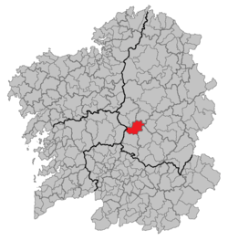
Location of Taboada
 Spain
Spain Galicia
[1]
[2]
(2023)[3]
27550
Taboada is a municipality in the province of Lugo, in the autonomous community of Galicia, Spain. It belongs to the comarca of Chantada. Taboada is a natural entry to the Ribeira Sacra.[4]
With a population of around 2700, distributed in 27 parishes, Taboada occupies an area of 146.67 square km, bordering with Antas de Ulla, Monterroso, Portomarín, Paradela, O Saviñao, Chantada (the capital city of the comarca) and Rodeiro.
References
- ^ "Confirmado el reparto de áreas en Taboada: así es el nuevo gobierno municipal". El Progreso de Lugo (in Spanish). 28 June 2023. Retrieved 29 August 2024.
- ^ "Entidades Locales". ssweb.seap.minhap.es. Retrieved 29 August 2024.
- ^ "Instituto Nacional de Estadística. (Spanish Statistical Institute)". www.ine.es. Retrieved 29 August 2024.
- ^ "AXENCIA GALEGA DA CALIDADE ALIMENTARIA" (PDF). ribeirasacra.org. Retrieved 29 August 2024.
- v
- t
- e
Municipalities in the province of Lugo
- Abadín
- Alfoz
- Antas de Ulla
- Baleira
- Baralla
- Barreiros
- Becerreá
- Begonte
- Bóveda
- Burela
- Carballedo
- Castro de Rei
- Castroverde
- Cervantes
- Cervo
- Chantada
- O Corgo
- Cospeito
- Folgoso do Courel
- A Fonsagrada
- Foz
- Friol
- Guitiriz
- Guntín
- O Incio
- Láncara
- Lourenzá
- Lugo
- Meira
- Mondoñedo
- Monforte de Lemos
- Monterroso
- Muras
- Navia de Suarna
- Negueira de Muñiz
- As Nogais
- Ourol
- Outeiro de Rei
- Palas de Rei
- Pantón
- Paradela
- O Páramo
- A Pastoriza
- Pedrafita do Cebreiro
- A Pobra do Brollón
- Pol
- A Pontenova
- Portomarín
- Quiroga
- Rábade
- Ribadeo
- Ribas de Sil
- Ribeira de Piquín
- Riotorto
- Samos
- Sarria
- O Saviñao
- Sober
- Taboada
- Trabada
- Triacastela
- O Valadouro
- O Vicedo
- Vilalba
- Viveiro
- Xermade
- Xove

42°42′58″N 7°45′47″W / 42.7161°N 7.7631°W / 42.7161; -7.7631
| Authority control databases |
|
|---|
 | This article about a location in the autonomous community of Galicia, Spain is a stub. You can help Wikipedia by expanding it. |
- v
- t
- e


