Tadmur District
District in Homs, Syria
Tadmur District منطقة تدمر | |
|---|---|
District | |
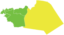 Map of Tadmur District within Homs Governorate | |
| Coordinates (Tadmur): 34°36′N 38°18′E / 34.6°N 38.3°E / 34.6; 38.3 | |
| Country |  Syria Syria |
| Governorate | Homs |
| Seat | Tadmur |
| Subdistricts | 2 nawāḥī |
| Area | |
| • Total | 30,823.49 km2 (11,901.02 sq mi) |
| Population (2004)[1] | |
| • Total | 76,942 |
| • Density | 2.5/km2 (6.5/sq mi) |
| Geocode | SY0405 |
Tadmur District (Arabic: منطقة تدمر, romanized: manṭiqat Tadmur) is a district of the Homs Governorate in central Syria. Administrative centre is the city of Tadmur, near ancient Palmyra/Tadmor. At the 2004 census, the district had a population of 76,942.[1]
Sub-districts
The district of Tadmur is divided into two sub-districts or nawāḥī (population as of 2004[1]):
- Tadmur Subdistrict (ناحية تدمر): population 55,062.[2]
- Al-Sukhnah Subdistrct (ناحية السخنة): population 21,880.[3]
References
- v
- t
- e
Districts of Syria
Homs Governorate | |
|
Homs Governorate | ||||||||||||||||||||||||||||||
|---|---|---|---|---|---|---|---|---|---|---|---|---|---|---|---|---|---|---|---|---|---|---|---|---|---|---|---|---|---|---|
|   | |||||||||||||||||||||||||||||
|
| ||||||||||||||||||||||||||||||
| ||||||||||||||||||||||||||||||
| ||||||||||||||||||||||||||||||
| ||||||||||||||||||||||||||||||
 | This article about a location in Homs Governorate, Syria is a stub. You can help Wikipedia by expanding it. |
- v
- t
- e


 Tadmur_District