Tangestan County
County in Bushehr province, Iran
You can help expand this article with text translated from the corresponding article in Persian. (April 2017) Click [show] for important translation instructions.
- Machine translation, like DeepL or Google Translate, is a useful starting point for translations, but translators must revise errors as necessary and confirm that the translation is accurate, rather than simply copy-pasting machine-translated text into the English Wikipedia.
- Do not translate text that appears unreliable or low-quality. If possible, verify the text with references provided in the foreign-language article.
- You must provide copyright attribution in the edit summary accompanying your translation by providing an interlanguage link to the source of your translation. A model attribution edit summary is
Content in this edit is translated from the existing Persian Wikipedia article at [[:fa:شهرستان تنگستان]]; see its history for attribution. - You may also add the template
{{Translated|fa|شهرستان تنگستان}}to the talk page. - For more guidance, see Wikipedia:Translation.
County in Bushehr, Iran
Tangestan County Persian: شهرستان تنگستان | |
|---|---|
County | |
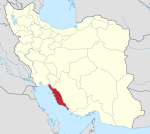
 Location of Tangestan County in Bushehr province (center, yellow) | |
 Location of Bushehr province in Iran | |
| Coordinates: 28°40′N 51°18′E / 28.667°N 51.300°E / 28.667; 51.300[1] | |
| Country |  Iran Iran |
| Province | Bushehr |
| Capital | Ahram |
| Districts | Central, Delvar |
| Population (2016)[2] | |
| • Total | 76,706 |
| Time zone | UTC+3:30 (IRST) |
| Tangestan County can be found at GEOnet Names Server, at this link, by opening the Advanced Search box, entering "9206091" in the "Unique Feature Id" form, and clicking on "Search Database". | |
Tangestan County (Persian: شهرستان تنگستان) is in Bushehr province, Iran. Its capital is the city of Ahram.[3]
History
After the 2011 National Census, the village of Abad was elevated to the status of the city of Shahrabad.[4]
Demographics
Population
At the time of the 2006 census, the county's population was 63,276 in 14,620 households.[5] The following census in 2011 counted 70,282 people in 18,268 households.[6] The 2016 census measured the population of the city as 76,706 in 22,080 households.[2]
Administrative divisions
Tangestan County's population history and administrative structure over three consecutive censuses are shown in the following table.
| Administrative Divisions | 2006[5] | 2011[6] | 2016[2] |
|---|---|---|---|
| Central District | 35,259 | 38,047 | 40,157 |
| Ahram RD | 10,990 | 11,632 | 8,689 |
| Baghak RD | 12,087 | 12,637 | 12,483 |
| Ahram (city) | 12,182 | 13,778 | 15,198 |
| Shahrabad (city)[a] | 3,787 | ||
| Delvar District | 28,017 | 32,154 | 36,481 |
| Bu ol Kheyr RD | 9,707 | 10,547 | 11,604 |
| Delvar RD | 15,109 | 17,903 | 20,435 |
| Delvar (city) | 3,201 | 3,704 | 4,442 |
| Total | 63,276 | 70,282 | 76,706 |
| RD = Rural District | |||
Overview
The Tangestan region in southern Iran is well known for its resistance to the invasion by British forces in the late 19th century. Tangestan County is the home of the group of people known as Tangesir. Rais Ali Delvari, the commander of Tangesiri fighters, is known as a national hero in the region. Tangestan is also famous in Iran for its high-quality dates.[citation needed]
See also
![]() Media related to Tangestan County at Wikimedia Commons
Media related to Tangestan County at Wikimedia Commons
 Iran portal
Notes
- ^ Formerly the village of Abad[4]
References
- ^ OpenStreetMap contributors (28 August 2024). "Tangestan County" (Map). openstreetmap.org (OpenStreetMap) (in Persian). Retrieved 28 August 2024.
- ^ a b c Census of the Islamic Republic of Iran, 1395 (2016): Bushehr Province. amar.org.ir (Report) (in Persian). The Statistical Center of Iran. Archived from the original (Excel) on 3 August 2017. Retrieved 19 December 2022.
- ^ Habibi, Hassan (c. 2024) [Approved 21 June 1369]. Approval of the organization and chain of citizenship of elements and units of the national divisions of Bushehr province centered on Bushehr city. lamtakam.com (Report) (in Persian). Ministry of the Interior, Political Defense Commission of the Government Board. Notification 82824/T138K. Archived from the original on 24 April 2024. Retrieved 24 April 2024 – via Lam ta Kam.
- ^ a b Rahimi, Mohammad Reza (c. 2023) [Approval 16 September 2013]. Approval letter regarding national divisions in Bushehr province. lamtakam.com (Report) (in Persian). Ministry of the Interior, Political and Defense Commission. Notification 186614/T47127K. Archived from the original on 1 December 2023. Retrieved 1 December 2023 – via Lam ta Kam.
- ^ a b Census of the Islamic Republic of Iran, 1385 (2006): Bushehr Province. amar.org.ir (Report) (in Persian). The Statistical Center of Iran. Archived from the original (Excel) on 20 September 2011. Retrieved 25 September 2022.
- ^ a b Census of the Islamic Republic of Iran, 1390 (2011): Bushehr Province. irandataportal.syr.edu (Report) (in Persian). The Statistical Center of Iran. Archived from the original (Excel) on 3 April 2023. Retrieved 19 December 2022 – via Iran Data Portal, Syracuse University.
External links
- http://www.itto.org/tourismattractions/?sight=2162
- http://tajikam.com/forums/showthread.php?p=7957
- v
- t
- e
Bushehr Province, Iran
| Asaluyeh County | |
|---|---|
| Bushehr County | |
| Dashtestan County | |
| Dashti County | |
| Deylam County | |
| Deyr County | |
| Ganaveh County | |
| Jam County | |
| Kangan County | |
| Tangestan County |
- Ghavam water tank (Ab Anbar of Ghavam)
- Khourmoj fire temple
- Boraazjan Castle
- Siraf
- Seensiz
- Rishahr
- Chehelkhaneh cave
- Bardak Siah Palace
- Saadat Mozaffari School
- Rais Ali Museum
- Bushehr anthropology Museum
- Gur-e-Dokhtar


