Contea di Reno

Questa voce sull'argomento contee del Kansas è solo un abbozzo.
Contribuisci a migliorarla secondo le convenzioni di Wikipedia.
| Contea di Reno contea | |
|---|---|
| Localizzazione | |
| Stato |  Stati Uniti Stati Uniti |
| Stato federato |  Kansas Kansas |
| Amministrazione | |
| Capoluogo | Hutchinson |
| Data di istituzione | 1867 |
| Territorio | |
| Coordinate del capoluogo | 37°47′04″N 98°00′01″W37°47′04″N, 98°00′01″W (Contea di Reno) |
| Superficie | 3 293 km² |
| Abitanti | 64 790 (2000) |
| Densità | 19,68 ab./km² |
| Altre informazioni | |
| Fuso orario | UTC-6 |
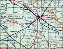
| Cartografia | |
  Hutchinson | |
 | |
| Sito istituzionale | |
| Modifica dati su Wikidata · Manuale | |
La contea di Reno, in inglese Reno County, è una contea dello Stato del Kansas, negli Stati Uniti. La popolazione al censimento del 2000 era di 64 790 abitanti. Il capoluogo di contea è Hutchinson
Geografia fisica
Secondo l'Ufficio del censimento statunitense, la contea ha una superficie di 3290 km² di cui (3250 km² è terra (98,7%) e 44 km² (1,3%) acque interne.
Contee confinanti
- Rice County (nord)
- McPherson County (northeast)
- Harvey County (est)
- Sedgwick County (southeast)
- Kingman County (sud)
- Pratt County (sudovest)
- Stafford County (ovest)
Storia
Geografia antropica

Città
- Abbyville
- Arlington
- Buhler
- Haven
- Hutchinson
- Langdon
- Nickerson
- Partridge
- Plevna
- Pretty Prairie
- South Hutchinson
- Sylvia
- Turon
- Willowbrook
Area non incorporata
- Yoder
Other unincorporated communities
- Castleton
- Darlow
- Medora
- Pleasantview
- St. Joe (Ost)
Ghost towns
- Huntsville
- Kent
- Lerado
- Olcott
- Sego
- Yaggy
Townships
Reno County is divided into thirty-one townships. The cities of Hutchinson and Nickerson are considered governmentally independent and are excluded from the census figures for the townships. In the following table, the population center is the largest city (or cities) included in that township's population total, if it is of a significant size.
| Township | FIPS | Centro di popolazione | Popolazione | Densità demografica | km² (/sq mi) | Water area km² (/sq mi) | Water % | Geographic coordinates |
|---|---|---|---|---|---|---|---|---|
| Albion | 00875 | Pretty Prairie | 837 | 9 (22) | 97 (38) | 0 (0) | 0,02% | 37°47′05″N 98°00′02″W37°47′05″N, 98°00′02″W |
| Arlington | 02350 | Arlington | 621 | 7 (17) | 94 (36) | 0 (0) | 0,03% | 37°53′16″N 98°11′01″W37°53′16″N, 98°11′01″W |
| Bell | 05350 | 87 | 1 (2) | 98 (38) | 0 (0) | 0,11% | 37°46′08″N 98°17′30″W37°46′08″N, 98°17′30″W | |
| Castleton | 11000 | 256 | 2 (5) | 140 (54) | 0 (0) | 0,01% | 37°51′44″N 97°57′06″W37°51′44″N, 97°57′06″W | |
| Center | 12050 | Partridge | 672 | 7 (19) | 94 (36) | 0 (0) | 0,17% | 37°57′38″N 98°05′23″W37°57′38″N, 98°05′23″W |
| Clay | 13600 | 3 302 | 38 (98) | 88 (34) | 1 (0) | 0,58% | 38°03′52″N 97°52′11″W38°03′52″N, 97°52′11″W | |
| Enterprise | 21475 | 139 | 1 (4) | 93 (36) | 0 (0) | 0,06% | 38°03′00″N 98°11′34″W38°03′00″N, 98°11′34″W | |
| Grant | 28025 | 1,307 | 11 (30) | 114 (44) | 1 (1) | 1,25% | 38°08′04″N 98°00′27″W38°08′04″N, 98°00′27″W | |
| Grove | 29025 | 64 | 1 (2) | 93 (36) | 0 (0) | 0,06% | 37°51′47″N 98°24′58″W37°51′47″N, 98°24′58″W | |
| Haven | 30750 | Haven | 1 592 | 11 (29) | 143 (55) | 1 (0) | 0,41% | 37°53′56″N 97°46′46″W37°53′56″N, 97°46′46″W |
| Hayes | 31000 | 106 | 1 (1) | 186 (72) | 0 (0) | 0,06% | 38°03′50″N 98°25′38″W38°03′50″N, 98°25′38″W | |
| Huntsville | 33550 | 118 | 1 (3) | 93 (36) | 0 (0) | 0,11% | 38°03′00″N 98°17′54″W38°03′00″N, 98°17′54″W | |
| Langdon | 38525 | Langdon | 160 | 2 (4) | 94 (36) | 0 (0) | 0,16% | 37°51′40″N 98°18′57″W37°51′40″N, 98°18′57″W |
| Lincoln | 41050 | 703 | 8 (20) | 93 (36) | 0 (0) | 0,07% | 37°57′46″N 97°58′07″W37°57′46″N, 97°58′07″W | |
| Little River | 41550 | Buhler | 1 881 | 20 (52) | 93 (36) | 1 (0) | 0,57% | 38°08′15″N 97°45′44″W38°08′15″N, 97°45′44″W |
| Loda | 41700 | 119 | 1 (3) | 98 (38) | 0 (0) | 0,27% | 37°47′02″N 98°12′22″W37°47′02″N, 98°12′22″W | |
| Medford | 45450 | 144 | 2 (5) | 83 (32) | 0 (0) | 0,18% | 38°08′14″N 98°12′24″W38°08′14″N, 98°12′24″W | |
| Medora | 45600 | 1 594 | 21 (53) | 77 (30) | 0 (0) | 0% | 38°08′40″N 97°51′03″W38°08′40″N, 97°51′03″W | |
| Miami | 46125 | Turon | 521 | 5 (14) | 98 (38) | 0 (0) | 0,15% | 37°47′33″N 98°25′03″W37°47′33″N, 98°25′03″W |
| Ninnescah | 50700 | 226 | 3 (7) | 79 (31) | 27 (10) | 25,53% | 37°47′09″N 97°51′27″W37°47′09″N, 97°51′27″W | |
| Plevna | 56750 | Plevna | 235 | 3 (6) | 94 (36) | 0 (0) | 0,04% | 37°58′01″N 98°18′36″W37°58′01″N, 98°18′36″W |
| Reno | 58975 | South Hutchinson | 4 496 | 50 (129) | 90 (35) | 2 (1) | 1,65% | 38°02′31″N 97°57′27″W38°02′31″N, 97°57′27″W |
| Roscoe | 61150 | 108 | 1 (3) | 98 (38) | 0 (0) | 0% | 37°46′11″N 98°04′23″W37°46′11″N, 98°04′23″W | |
| Salt Creek | 62850 | 483 | 3 (9) | 139 (54) | 1 (0) | 0,39% | 38°03′48″N 98°05′57″W38°03′48″N, 98°05′57″W | |
| Sumner | 69200 | 547 | 5 (13) | 106 (41) | 7 (3) | 6,13% | 37°46′24″N 97°45′51″W37°46′24″N, 97°45′51″W | |
| Sylvia | 69825 | Sylvia | 393 | 4 (11) | 93 (36) | 0 (0) | 0,34% | 37°57′24″N 98°24′46″W37°57′24″N, 98°24′46″W |
| Troy | 71600 | 112 | 1 (3) | 94 (36) | 0 (0) | 0,16% | 37°51′56″N 98°05′25″W37°51′56″N, 98°05′25″W | |
| Valley | 73075 | 887 | 6 (16) | 143 (55) | 1 (0) | 0,90% | 38°00′33″N 97°45′02″W38°00′33″N, 97°45′02″W | |
| Walnut | 75100 | 114 | 1 (3) | 94 (36) | 0 (0) | 0% | 38°07′40″N 98°18′07″W38°07′40″N, 98°18′07″W | |
| Westminster | 77175 | Abbyville | 243 | 3 (7) | 94 (36) | 0 (0) | 0% | 37°57′48″N 98°12′23″W37°57′48″N, 98°12′23″W |
| Yoder | 80775 | 742 | 8 (20) | 96 (37) | 1 (0) | 1,03% | 37°56′54″N 97°52′34″W37°56′54″N, 97°52′34″W |
Altri progetti
Altri progetti
- Wikimedia Commons
 Wikimedia Commons contiene immagini o altri file su contea di Reno
Collegamenti esterni
- (EN) Sito ufficiale, su RenoGov.org.

- (EN) Contea di Reno, su Geographic Names Information System, USGS.

V · D · M | |
|---|---|
| Contee | Allen · Anderson · Atchison · Barber · Barton · Bourbon · Brown · Butler · Chase · Chautauqua · Cherokee · Cheyenne · Clark · Clay · Cloud · Coffey · Comanche · Cowley · Crawford · Decatur · Dickinson · Doniphan · Douglas · Edwards · Elk · Ellis · Ellsworth · Finney · Ford · Franklin · Geary · Gove · Graham · Grant · Gray · Greeley · Greenwood · Hamilton · Harper · Harvey · Haskell · Hodgeman · Jackson · Jefferson · Jewell · Johnson · Kearny · Kingman · Kiowa · Labette · Lane · Leavenworth · Lincoln · Linn · Logan · Lyon · Marion · Marshall · McPherson · Meade · Miami · Mitchell · Montgomery · Morris · Morton · Nemaha · Neosho · Ness · Norton · Osage · Osborne · Ottawa · Pawnee · Phillips · Pottawatomie · Pratt · Rawlins · Reno · Republic · Rice · Riley · Rooks · Rush · Russell · Saline · Scott · Sedgwick · Seward · Shawnee · Sheridan · Sherman · Smith · Stafford · Stanton · Stevens · Sumner · Thomas · Trego · Wabaunsee · Wallace · Washington · Wichita · Wilson · Woodson · Wyandotte |
| Regioni | Altopiano d'Ozark · Area metropolitana di Kansas City · Cherokee Strip · East Central · Flint Hills · High Plains · Red Hills · Smoky Hills · Southeast |
| Aree metropolitane | Capitale: Topeka Maggiori città: Derby · Dodge City · Emporia · Garden City · Hays · Hutchinson · Kansas City · Lawrence · Leavenworth · Leawood · Lenexa · Liberal · Manhattan · Olathe · Overland Park · Prairie Village · Salina · Shawnee · Topeka · Wichita |
| Controllo di autorità | VIAF (EN) 158279377 · LCCN (EN) n80145850 · GND (DE) 4601719-7 · J9U (EN, HE) 987007562063005171 |
|---|
 Portale Stati Uniti d'America: accedi alle voci di Wikipedia che parlano degli Stati Uniti d'America


