South East England
| Region | |||
 Wybrzeże klifowe w Dover | |||
| Państwo |
| ||
|---|---|---|---|
| Kraj |
| ||
| Powierzchnia | 19 070 km² | ||
| Populacja (2021) • liczba ludności |
| ||
| • gęstość | 487 os./km² | ||
Położenie na mapie | |||
| |||
| |||
| Strona internetowa | |||


South East England (South East) – jeden z dziewięciu regionów Anglii, obejmujący jej południowo-wschodnią część. Zajmuje powierzchnię 19 070 km² (15% terytorium Anglii)[1], w 2021 roku zamieszkany był przez 9 294 800 osób (16% ludności Anglii)[2].
Największe miasta regionu to Southampton (liczba mieszkańców w 2011 r. – 253 651), Portsmouth (238 137), Brighton and Hove (229 700), Reading (218 705), Milton Keynes (171 750), Oksford (159 994), Slough (155 298) i High Wycombe (120 256)[3].
Najwyższym punktem jest Walbury Hill, w hrabstwie Berkshire, o wysokości 297 m n.p.m[4].
Podział terytorialny
Region South East obejmuje dziewięć hrabstw ceremonialnych. Podzielony jest na 19 jednostek administracyjnych niższego rzędu: 6 hrabstw niemetropolitalnych i 13 jednostek typu unitary authority[5].
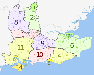
| Nr na mapie | Hrabstwo ceremonialne | Hrabstwo niemetropolitalne | Dystrykt niemetropolitalny |
|---|---|---|---|
| lub jednostka typu unitary authority | |||
| 1a | Berkshire | West Berkshire | |
| 1b | Reading | ||
| 1c | Wokingham | ||
| 1d | Bracknell Forest | ||
| 1e | Windsor and Maidenhead | ||
| 1f | Slough | ||
| 2 | Buckinghamshire | Buckinghamshire | |
| 3 | Milton Keynes | ||
| 4a | East Sussex | East Sussex | Hastings |
| 4b | Rother | ||
| 4c | Wealden | ||
| 4d | Eastbourne | ||
| 4e | Lewes | ||
| 5 | Brighton and Hove | ||
| 6a | Kent | Kent | Dartford |
| 6b | Gravesham | ||
| 6c | Sevenoaks | ||
| 6d | Tonbridge and Malling | ||
| 6e | Tunbridge Wells | ||
| 6f | Maidstone | ||
| 6g | Swale | ||
| 6h | Ashford | ||
| 6i | Folkestone and Hythe | ||
| 6j | Canterbury | ||
| 6k | Dover | ||
| 6l | Thanet | ||
| 7 | Medway | ||
| 8a | Oxfordshire | Oxfordshire | Oksford |
| 8b | Cherwell | ||
| 8c | South Oxfordshire | ||
| 8d | Vale of White Horse | ||
| 8e | West Oxfordshire | ||
| 9a | Surrey | Surrey | Spelthorne |
| 9b | Runnymede | ||
| 9c | Surrey Heath | ||
| 9d | Woking | ||
| 9e | Elmbridge | ||
| 9f | Guildford | ||
| 9g | Waverley | ||
| 9h | Mole Valley | ||
| 9i | Epsom and Ewell | ||
| 9j | Reigate and Banstead | ||
| 9k | Tandridge | ||
| 10a | West Sussex | West Sussex | Worthing |
| 10b | Arun | ||
| 10c | Chichester | ||
| 10d | Horsham | ||
| 10e | Crawley | ||
| 10f | Mid Sussex | ||
| 10g | Adur | ||
| 11a | Hampshire | Hampshire | Fareham |
| 11b | Gosport | ||
| 11c | Winchester | ||
| 11d | Havant | ||
| 11e | East Hampshire | ||
| 11f | Hart | ||
| 11g | Rushmoor | ||
| 11h | Basingstoke and Deane | ||
| 11i | Test Valley | ||
| 11j | Eastleigh | ||
| 11k | New Forest | ||
| 12 | Southampton | ||
| 13 | Portsmouth | ||
| 14 | Wight | Wight | |
Przypisy
- ↑ Census 2011: Usual resident population. Nomis. [dostęp 2023-02-27]. (ang.).
- ↑ Labour Market Profile - South East. Nomis. [dostęp 2023-02-27]. (ang.).
- ↑ KS101EW - Usual resident population. Nomis. [dostęp 2023-02-27]. (ang.).
- ↑ Facts about South East England. Visit South East England. [dostęp 2023-02-27]. (ang.).
- ↑ South East. [w:] Open Data [on-line]. Department for Levelling Up, Housing and Communities. [dostęp 2023-02-27]. (ang.).
- p
- d
- e


