List of national monuments in County Dublin
Map all coordinates using OpenStreetMap
Download coordinates as:
- KML
- GPX (all coordinates)
- GPX (primary coordinates)
- GPX (secondary coordinates)
The Irish state has officially approved the following list of national monuments in County Dublin and the city of Dublin. In the Republic of Ireland, a structure or site may be deemed to be a "national monument", and therefore worthy of state protection unless the government decides to demolish it. If the land adjoining the monument is essential to protect it, this land may also be protected.
National Monuments
| NM# | Monument name | Description | Image | Townland | Location |
|---|---|---|---|---|---|
| 310 | Baldongan Church | Church & Tower | 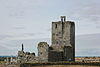 | Baldongan | 53°33′11″N 6°07′44″W / 53.55316°N 6.128776°W / 53.55316; -6.128776 (Baldongan Church and Tower) |
| 437 | Ballyedmonduff Wedge Tomb | Wedge Tomb |  | Ballyedmonduff | 53°13′45″N 6°13′34″W / 53.229167°N 6.2262°W / 53.229167; -6.2262 |
| 590 | Balrothery Tower | Church Tower | 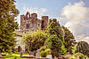 | Balrothery | 53°35′12″N 6°11′24″W / 53.586546°N 6.190072°W / 53.586546; -6.190072 (Balrothery Tower) |
| 291 | Brennanstown Portal Tomb | Portal Tomb |  | Brennanstown | 53°15′14″N 6°09′32″W / 53.253794°N 6.158762°W / 53.253794; -6.158762 |
| 32 | Clondalkin Round Tower | Round Tower & Cross |  | Clondalkin | 53°19′19″N 6°23′43″W / 53.322065°N 6.395374°W / 53.322065; -6.395374 (Clondalkin Tower) |
| 285 | Tully's Castle | Castle |  | Clondalkin | 53°19′15″N 6°23′24″W / 53.320812°N 6.389957°W / 53.320812; -6.389957 (Tully's Castle) |
| 444 | Archbold's Castle | Castle |  | Dalkey | 53°16′40″N 6°06′23″W / 53.27789°N 6.106422°W / 53.27789; -6.106422 (Archbold's Castle) |
| 33 | Dalkey Island Church | Church |  | Dalkey Island | 53°16′22″N 6°05′08″W / 53.272685°N 6.085509°W / 53.272685; -6.085509 (Dalkey Island Church) |
| 401 | St. Mary's Abbey | Abbey (Cistercian) (Chapter house) |  | Northside Dublin | 53°20′51″N 6°16′09″W / 53.3475°N 6.269167°W / 53.3475; -6.269167 (St. Mary's Abbey) |
| 34 | St. Audoen's Church | Church |  | Southside Dublin | 53°20′37″N 6°16′27″W / 53.34374°N 6.27417°W / 53.34374; -6.27417 (St. Audoen's Church) |
| St. Stephen's Green | Park | 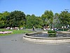 | Southside Dublin | 53°20′17″N 6°15′33″W / 53.338056°N 6.259167°W / 53.338056; -6.259167 (St. Stephen's Green) | |
| 230 | Dunsoghly Castle | Castle |  | Dunsoghly | 53°25′37″N 6°19′06″W / 53.426936°N 6.318277°W / 53.426936; -6.318277 (Dunsoghly Castle) |
| 276 | Glencullen Standing Stone | Standing Stone |  | Glencullen | 53°13′11″N 6°13′03″W / 53.219771°N 6.217385°W / 53.219771; -6.217385 (Glencullen Standing Stone) |
| 605 | Grange Abbey | Church |  | Donaghmede | 53°23′57″N 6°09′38″W / 53.399075°N 6.160429°W / 53.399075; -6.160429 (Grange Abbey) |
| 36 | Howth Church | Church |  | Howth | 53°23′15″N 6°03′57″W / 53.387515°N 6.065961°W / 53.387515; -6.065961 (Howth Church) |
| 226 | Kilgobbin Cross | Cross |  | Kilgobbin | 53°15′23″N 6°13′04″W / 53.256478°N 6.217806°W / 53.256478; -6.217806 (Kilgobbin High Cross) |
| 207, 587 | Kill of the Grange | Church, Well & Bullaun Stone |  | Kill of the Grange | 53°16′53″N 6°09′40″W / 53.281378°N 6.160987°W / 53.281378; -6.160987 (Kill of the Grange Church, Well and Bullaun Stone) |
| 35 | Cill Iníon Léinín | Church | 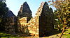 | Killiney | 53°15′17″N 6°06′59″W / 53.254727°N 6.116315°W / 53.254727; -6.116315 (Killiney Church) |
| 675 | Kilmainham Gaol | Prison |  | Kilmainham | 53°20′31″N 6°18′35″W / 53.341944°N 6.309722°W / 53.341944; -6.309722 (Kilmainham Gaol) |
| 493 | Kilmashogue | Wedge Tomb | 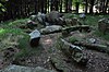 | Rathfarnham | 53°15′28″N 6°16′32″W / 53.2576987°N 6.2755741°W / 53.2576987; -6.2755741 (Kilmashogue) |
| 343 | Kiltiernan Tomb | Portal Tomb | Kiltiernan | 53°14′20″N 6°12′26″W / 53.2388225°N 6.2071451°W / 53.2388225; -6.2071451 (Kiltiernan Portal Tomb) | |
| 216 | Laughanstown | Crosses and wedge tomb | 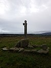 | Laughanstown | 53°14′32″N 6°09′06″W / 53.242275°N 6.151569°W / 53.242275; -6.151569 (Laughanstown crosses and wedge tomb) |
| 225 | Tully Church | Church |  | Laughanstown | 53°14′49″N 6°09′08″W / 53.246818°N 6.152242°W / 53.246818; -6.152242 |
| 157 | Lusk | Round Tower & Church Tower |  | Lusk | 53°31′34″N 6°10′02″W / 53.526116°N 6.167295°W / 53.526116; -6.167295 (Lusk Round Tower and Church Tower) |
| 302 | Casino at Marino | Demesne Building |  | Marino | 53°22′16″N 6°13′37″W / 53.37124°N 6.22703°W / 53.37124; -6.22703 (Casino at Marino) |
| 494 | Monkstown Castle | Castle | 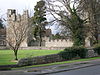 | Monkstown | 53°17′20″N 6°09′02″W / 53.288911°N 6.15065°W / 53.288911; -6.15065 (Monkstown Castle) |
| 628 | Rathfarnham Castle | Castle or Fortified House |  | Rathfarnham | 53°17′53″N 6°17′01″W / 53.298099°N 6.283609°W / 53.298099; -6.283609 (Rathfarnham Castle) |
| 162 | Rathmichael | Early Medieval Ecclesiastical Site |  | Rathmichael | 53°13′58″N 6°08′46″W / 53.23288°N 6.14600°W / 53.23288; -6.14600 (Rathmichael) |
| 340 | Swords Castle | Castle |  | Swords | 53°27′35″N 6°13′12″W / 53.45980°N 6.22004°W / 53.45980; -6.22004 (Swords Castle) |
| 464 | Tibradden | Cairn |  | Rathfarnham | 53°14′19″N 6°16′49″W / 53.23862°N 6.28031°W / 53.23862; -6.28031 (Tibradden) |
Sources
- National Monuments in Dublin, County and City


